
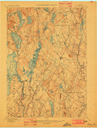
~ Gray ME topo map, 1:62500 scale, 15 X 15 Minute, Historical, 1898, updated 1902
Gray, Maine, USGS topographic map dated 1898.
Includes geographic coordinates (latitude and longitude). This topographic map is suitable for hiking, camping, and exploring, or framing it as a wall map.
Printed on-demand using high resolution imagery, on heavy weight and acid free paper, or alternatively on a variety of synthetic materials.
Topos available on paper, Waterproof, Poly, or Tyvek. Usually shipping rolled, unless combined with other folded maps in one order.
- Product Number: USGS-5536549
- Free digital map download (high-resolution, GeoPDF): Gray, Maine (file size: 7 MB)
- Map Size: please refer to the dimensions of the GeoPDF map above
- Weight (paper map): ca. 55 grams
- Map Type: POD USGS Topographic Map
- Map Series: HTMC
- Map Verison: Historical
- Cell ID: 54801
- Scan ID: 807516
- Imprint Year: 1902
- Survey Year: 1892
- Datum: Unstated
- Map Projection: Unstated
- Map published by United States Geological Survey
- Map Language: English
- Scanner Resolution: 508 dpi
- Map Cell Name: Gray
- Grid size: 15 X 15 Minute
- Date on map: 1898
- Map Scale: 1:62500
- Geographical region: Maine, United States
Neighboring Maps:
All neighboring USGS topo maps are available for sale online at a variety of scales.
Spatial coverage:
Topo map Gray, Maine, covers the geographical area associated the following places:
- North Windham - Ireland Corner - South Gray - Windham Center - Glantz Corner - Shaker Village - New Gloucester - North Raymond - Suckerville - Crescent Lake - Baker Corner - Whites Corner - Raymond - East Gray - Newhall - Gates Hill (historical) - Scotland - North Gorham - Cumberland Center - Intervale - Great Falls (historical) - Gray - White Rock - Cumberland Center Station - Blackstrap - North Gray - West Cumberland - Dry Mills - Dog Corner - Lowells Corner (historical) - Dolley Corner - East Raymond - Upper Gloucester - Popeville - Fosters Corner - Windham Hill - North Falmouth - West Gray
- Map Area ID: AREA4443.75-70.5-70.25
- Northwest corner Lat/Long code: USGSNW44-70.5
- Northeast corner Lat/Long code: USGSNE44-70.25
- Southwest corner Lat/Long code: USGSSW43.75-70.5
- Southeast corner Lat/Long code: USGSSE43.75-70.25
- Northern map edge Latitude: 44
- Southern map edge Latitude: 43.75
- Western map edge Longitude: -70.5
- Eastern map edge Longitude: -70.25


