
~ Grand Lake Seboeis ME topo map, 1:62500 scale, 15 X 15 Minute, Historical, 1954, updated 1958
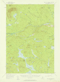
Grand Lake Seboeis, Maine, USGS topographic map dated 1954.
Includes geographic coordinates (latitude and longitude). This topographic map is suitable for hiking, camping, and exploring, or framing it as a wall map.
Printed on-demand using high resolution imagery, on heavy weight and acid free paper, or alternatively on a variety of synthetic materials.
Topos available on paper, Waterproof, Poly, or Tyvek. Usually shipping rolled, unless combined with other folded maps in one order.
- Product Number: USGS-5536533
- Free digital map download (high-resolution, GeoPDF): Grand Lake Seboeis, Maine (file size: 5 MB)
- Map Size: please refer to the dimensions of the GeoPDF map above
- Weight (paper map): ca. 55 grams
- Map Type: POD USGS Topographic Map
- Map Series: HTMC
- Map Verison: Historical
- Cell ID: 54748
- Scan ID: 306586
- Imprint Year: 1958
- Woodland Tint: Yes
- Aerial Photo Year: 1954
- Field Check Year: 1954
- Datum: NAD27
- Map Projection: Polyconic
- Map published by United States Geological Survey
- Map Language: English
- Scanner Resolution: 600 dpi
- Map Cell Name: Grand Lake Seboeis
- Grid size: 15 X 15 Minute
- Date on map: 1954
- Map Scale: 1:62500
- Geographical region: Maine, United States
Neighboring Maps:
All neighboring USGS topo maps are available for sale online at a variety of scales.
Spatial coverage:
Topo map Grand Lake Seboeis, Maine, covers the geographical area associated the following places:
- Foster Camp - Carey Brook - Coombs Brook - Malcolm Branch - Smith Brook - Batch Pond - Smith Brook Deadwater - Grand Lake Seboeis - Wadleigh Brook - Isthmus Pond - Junkins Camp - South Branch Wadleigh Brook - Chandler Deadwater - Cut Brook - Spoon Mountain - East Branch Carry Brook - Cut Lake Stream - Dunn Camp - Little Smith Brook - Flying Hill - T8 R6 WELS - Carry Pond - Plantation of Oxbow - Whipple Camp - Dead Brook - Dead Brook - T8 R7 WELS - McLean Ridge - Old Maid Rock - Coombs Cove - Boody Pond - Smith Brook Ridge - Hayden Brook - LaPomkeag Lake - Farm Camp Brook - Gilman Beach - Dead Brook - Snowshoe Lake - Fourmile Brook - Lost Pond - Lower Deadwater - Wadleigh Mountain - T9 R7 WELS - Sugar Berth Ridge - Oxbow Checkpoint Building - Chamberlain Brook - Millinocket Lake Tote Road - LaPomkeag Stream - Carey Lake - Cut Lake - Umcolcus Deadwater - Hart Camp - Cranberry Pond - Little Sawtelle Pond - Burnt Pond - Osgood Deadwater - Carry Brook - Salmon Pool - Dead Brook Deadwater - Jameson Ridge - Chase Camp - Chandler Lake - Swett Ridge - Mooseleuk Stream - Arbo Flats - Jones Pond - North Branch Wadleigh Brook - Turtle Brook - Pickerel Point - Manton Pond - Jones Brook - West Branch Carry Brook - Chandler Mountain - Orr Ridge - Chamberlain Pond - Rock Dam - Upper Deadwater - Junkins Island - Bastc Rips - Cunningham Mountains - Sawtelle Pond - Botting Cemetery - T7 R6 WELS - South Branch Otter Brook - Lower LaPomkeag Lake - Batch Brook - Frazier Camp - The Narrows - Botting Pond - Boody Cove - T7 R7 WELS
- Map Area ID: AREA46.546.25-68.75-68.5
- Northwest corner Lat/Long code: USGSNW46.5-68.75
- Northeast corner Lat/Long code: USGSNE46.5-68.5
- Southwest corner Lat/Long code: USGSSW46.25-68.75
- Southeast corner Lat/Long code: USGSSE46.25-68.5
- Northern map edge Latitude: 46.5
- Southern map edge Latitude: 46.25
- Western map edge Longitude: -68.75
- Eastern map edge Longitude: -68.5


