
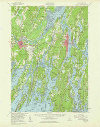
~ Bath ME topo map, 1:62500 scale, 15 X 15 Minute, Historical, 1957, updated 1960
Bath, Maine, USGS topographic map dated 1957.
Includes geographic coordinates (latitude and longitude). This topographic map is suitable for hiking, camping, and exploring, or framing it as a wall map.
Printed on-demand using high resolution imagery, on heavy weight and acid free paper, or alternatively on a variety of synthetic materials.
Topos available on paper, Waterproof, Poly, or Tyvek. Usually shipping rolled, unless combined with other folded maps in one order.
- Product Number: USGS-5536063
- Free digital map download (high-resolution, GeoPDF): Bath, Maine (file size: 8 MB)
- Map Size: please refer to the dimensions of the GeoPDF map above
- Weight (paper map): ca. 55 grams
- Map Type: POD USGS Topographic Map
- Map Series: HTMC
- Map Verison: Historical
- Cell ID: 51008
- Scan ID: 306458
- Imprint Year: 1960
- Woodland Tint: Yes
- Edit Year: 1957
- Survey Year: 1941
- Datum: NAD27
- Map Projection: Polyconic
- Map published by United States Geological Survey
- Map published by United States Army Corps of Engineers
- Map published by United States Army
- Map Language: English
- Scanner Resolution: 600 dpi
- Map Cell Name: Bath
- Grid size: 15 X 15 Minute
- Date on map: 1957
- Map Scale: 1:62500
- Geographical region: Maine, United States
Neighboring Maps:
All neighboring USGS topo maps are available for sale online at a variety of scales.
Spatial coverage:
Topo map Bath, Maine, covers the geographical area associated the following places:
- Winnegance - Linnhaven West - Perry Cove - Marrtown - Bath - Orrs Island - Sebasco - Wynburg (historical) - North Harpswell - Harpswell Center - Sebasco Estates - Fort Popham - Ashdale - Parker Head - Dyer Cove - Phippsburg - Meadowbrook - Bay Point - East Harpswell - Nequasset - Popham Beach - Brunswick - Cathance - Harding - Sabino - Woolwich - Pennellville - Cooks Corner - Days Ferry - Gumet (historical) - Topsham - Arrowsic - Nequsset (historical) - North Bath - Dyer Corner - North Meadows - West Georgetown - Brightwater - Merrymeeting Trailer Park - Brighams Cove - Cundys Harbor
- Map Area ID: AREA4443.75-70-69.75
- Northwest corner Lat/Long code: USGSNW44-70
- Northeast corner Lat/Long code: USGSNE44-69.75
- Southwest corner Lat/Long code: USGSSW43.75-70
- Southeast corner Lat/Long code: USGSSE43.75-69.75
- Northern map edge Latitude: 44
- Southern map edge Latitude: 43.75
- Western map edge Longitude: -70
- Eastern map edge Longitude: -69.75


