
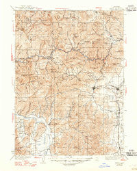
~ Yreka CA topo map, 1:125000 scale, 30 X 30 Minute, Historical, 1939, updated 1947
Yreka, California, USGS topographic map dated 1939.
Includes geographic coordinates (latitude and longitude). This topographic map is suitable for hiking, camping, and exploring, or framing it as a wall map.
Printed on-demand using high resolution imagery, on heavy weight and acid free paper, or alternatively on a variety of synthetic materials.
Topos available on paper, Waterproof, Poly, or Tyvek. Usually shipping rolled, unless combined with other folded maps in one order.
- Product Number: USGS-5506475
- Free digital map download (high-resolution, GeoPDF): Yreka, California (file size: 11 MB)
- Map Size: please refer to the dimensions of the GeoPDF map above
- Weight (paper map): ca. 55 grams
- Map Type: POD USGS Topographic Map
- Map Series: HTMC
- Map Verison: Historical
- Cell ID: 66989
- Scan ID: 302109
- Imprint Year: 1947
- Survey Year: 1932
- Datum: NAD27
- Map Projection: Polyconic
- Map published by United States Geological Survey
- Map Language: English
- Scanner Resolution: 600 dpi
- Map Cell Name: Yreka
- Grid size: 30 X 30 Minute
- Date on map: 1939
- Map Scale: 1:125000
- Geographical region: California, United States
Neighboring Maps:
All neighboring USGS topo maps are available for sale online at a variety of scales.
Spatial coverage:
Topo map Yreka, California, covers the geographical area associated the following places:
- Fort Jones - Yreka - Hornbrook - Gazelle - Cinnabar Springs (historical) - Henley - Hooperville (historical) - Cascade Sun Mobile Home Estates - Cove Mobile Villa - Horizon Hills Mobile Home Park - Ranch Mobile Home Park - Jims Camp - Walker - Klamath River - Swiss Bar - Oak Ridge Mobile Estates - Greenview - Hawkinsville - Gottsville - Mugginsville - Grenada - Oaks Mobile Home And Recreational Vehicle Park - Oro Fino - Cheeseville - Horse Creek - Montague - Nickels Mobile Park - Hilt - Oakbar
- Map Area ID: AREA4241.5-123-122.5
- Northwest corner Lat/Long code: USGSNW42-123
- Northeast corner Lat/Long code: USGSNE42-122.5
- Southwest corner Lat/Long code: USGSSW41.5-123
- Southeast corner Lat/Long code: USGSSE41.5-122.5
- Northern map edge Latitude: 42
- Southern map edge Latitude: 41.5
- Western map edge Longitude: -123
- Eastern map edge Longitude: -122.5


