
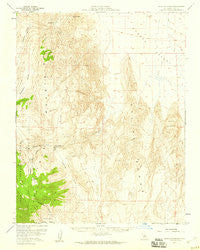
~ Waucoba Spring CA topo map, 1:62500 scale, 15 X 15 Minute, Historical, 1958, updated 1959
Waucoba Spring, California, USGS topographic map dated 1958.
Includes geographic coordinates (latitude and longitude). This topographic map is suitable for hiking, camping, and exploring, or framing it as a wall map.
Printed on-demand using high resolution imagery, on heavy weight and acid free paper, or alternatively on a variety of synthetic materials.
Topos available on paper, Waterproof, Poly, or Tyvek. Usually shipping rolled, unless combined with other folded maps in one order.
- Product Number: USGS-5505043
- Free digital map download (high-resolution, GeoPDF): Waucoba Spring, California (file size: 7 MB)
- Map Size: please refer to the dimensions of the GeoPDF map above
- Weight (paper map): ca. 55 grams
- Map Type: POD USGS Topographic Map
- Map Series: HTMC
- Map Verison: Historical
- Cell ID: 64295
- Scan ID: 301954
- Imprint Year: 1959
- Woodland Tint: Yes
- Aerial Photo Year: 1952
- Survey Year: 1958
- Datum: NAD27
- Map Projection: Polyconic
- Map published by United States Geological Survey
- Map Language: English
- Scanner Resolution: 600 dpi
- Map Cell Name: Waucoba Spring
- Grid size: 15 X 15 Minute
- Date on map: 1958
- Map Scale: 1:62500
- Geographical region: California, United States
Neighboring Maps:
All neighboring USGS topo maps are available for sale online at a variety of scales.
Spatial coverage:
Topo map Waucoba Spring, California, covers the geographical area associated the following places:
- Marble Canyon - Hanging Rock Canyon - North Pass - Friend Prospect - Opal Mine - Harlis and Broady Mine - Lime Hill - Opal Canyon - KIFS Prospect - Silver Spur Prospect - Joshua Flats - Good Enough Prospect - Whippoorwill Canyon - Eureka Peak - Whippoorwill Flat - Iron Nugget Placer Mine - Jean Apex Prospect - Jackass Flats - Jackass Canyon - Waucoba Spring - Saline Range - Nikolaus Eureka Mine
- Map Area ID: AREA37.2537-118-117.75
- Northwest corner Lat/Long code: USGSNW37.25-118
- Northeast corner Lat/Long code: USGSNE37.25-117.75
- Southwest corner Lat/Long code: USGSSW37-118
- Southeast corner Lat/Long code: USGSSE37-117.75
- Northern map edge Latitude: 37.25
- Southern map edge Latitude: 37
- Western map edge Longitude: -118
- Eastern map edge Longitude: -117.75


