
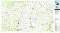
~ Taylor TX topo map, 1:100000 scale, 30 X 60 Minute, Historical, 1985, updated 1986
Taylor, Texas, USGS topographic map dated 1985.
Includes geographic coordinates (latitude and longitude). This topographic map is suitable for hiking, camping, and exploring, or framing it as a wall map.
Printed on-demand using high resolution imagery, on heavy weight and acid free paper, or alternatively on a variety of synthetic materials.
Topos available on paper, Waterproof, Poly, or Tyvek. Usually shipping rolled, unless combined with other folded maps in one order.
- Product Number: USGS-5480159
- Free digital map download (high-resolution, GeoPDF): Taylor, Texas (file size: 20 MB)
- Map Size: please refer to the dimensions of the GeoPDF map above
- Weight (paper map): ca. 55 grams
- Map Type: POD USGS Topographic Map
- Map Series: HTMC
- Map Verison: Historical
- Cell ID: 68443
- Scan ID: 123463
- Imprint Year: 1986
- Woodland Tint: Yes
- Visual Version Number: 1
- Aerial Photo Year: 1981
- Edit Year: 1985
- Datum: NAD27
- Map Projection: Universal Transverse Mercator
- Planimetric: Yes
- Map published by United States Geological Survey
- Map Language: English
- Scanner Resolution: 600 dpi
- Map Cell Name: Taylor
- Grid size: 30 X 60 Minute
- Date on map: 1985
- Map Scale: 1:100000
- Geographical region: Texas, United States
Neighboring Maps:
All neighboring USGS topo maps are available for sale online at a variety of scales.
Spatial coverage:
Topo map Taylor, Texas, covers the geographical area associated the following places:
- Corinth - Salty - Mozo - Pettibone - Prairie Dell - Little River - South Elm - Granger - Theon - Thorndale - Florence - Taylor - Val Verde - Waterloo - Donahoe - Mahomet - Sommers Mill - White Stone - Round Rock - Schwertner - Joe Lee - Youngsport - Serenada - Thrall - Academy - Praesel - North Elm - Conoley - Friendship - Jonah - Wuthrich Hill - Georgetown - Little River-Academy - Sandoval - North Georgetown - Elm Ridge - Ding Dong - Vilas - Noack - Hare - Marjorie - Tracy - Sonterra - Ding Dong - Salado - Sharp - Nameless - Cedar Park - Hutto - Brushy Creek - Corn Hill - Walkerton - Frame Switch - Alcoa - Sparks - San Gabriel - New Colony - Sandow - Jarrell - Hunt Crossing - Holland - Seward Junction - Round Mountain - Pleasant Hill - Childers Mill (historical) - Meeks - Rockdale - Oakalla - Salem - Greens Crossing - Serenada - Beyersville - Edgeworth - Russell Crossing - Laneport - Andice - Walburg - Cedar Valley - Keelersville - Circleville - Bartlett - Berrys Creek - Leedale - Rogers - Handy - Leander - Bowers - Elm Grove - Weir - Jinks Branch - Buckholts - Liberty Hill - Liberty Hill - Sun City - The Crossroads - Hoxie - Cummins Crossing - Maxdale - Davilla - Briggs
- Map Area ID: AREA3130.5-98-97
- Northwest corner Lat/Long code: USGSNW31-98
- Northeast corner Lat/Long code: USGSNE31-97
- Southwest corner Lat/Long code: USGSSW30.5-98
- Southeast corner Lat/Long code: USGSSE30.5-97
- Northern map edge Latitude: 31
- Southern map edge Latitude: 30.5
- Western map edge Longitude: -98
- Eastern map edge Longitude: -97


