
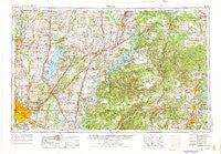
~ Tulsa OK topo map, 1:250000 scale, 1 X 2 Degree, Historical, 1958, updated 1975
Tulsa, Oklahoma, USGS topographic map dated 1958.
Includes geographic coordinates (latitude and longitude). This topographic map is suitable for hiking, camping, and exploring, or framing it as a wall map.
Printed on-demand using high resolution imagery, on heavy weight and acid free paper, or alternatively on a variety of synthetic materials.
Topos available on paper, Waterproof, Poly, or Tyvek. Usually shipping rolled, unless combined with other folded maps in one order.
- Product Number: USGS-5473191
- Free digital map download (high-resolution, GeoPDF): Tulsa, Oklahoma (file size: 19 MB)
- Map Size: please refer to the dimensions of the GeoPDF map above
- Weight (paper map): ca. 55 grams
- Map Type: POD USGS Topographic Map
- Map Series: HTMC
- Map Verison: Historical
- Cell ID: 69064
- Scan ID: 707641
- Imprint Year: 1975
- Woodland Tint: Yes
- Photo Revision Year: 1973
- Aerial Photo Year: 1973
- Edit Year: 1973
- Field Check Year: 1958
- Datum: Unstated
- Map Projection: Transverse Mercator
- Map published by: Military, Other
- Map Language: English
- Scanner Resolution: 508 dpi
- Map Cell Name: Tulsa
- Grid size: 1 X 2 Degree
- Date on map: 1958
- Map Scale: 1:250000
- Geographical region: Oklahoma, United States
Neighboring Maps:
All neighboring USGS topo maps are available for sale online at a variety of scales.
Spatial coverage:
Topo map Tulsa, Oklahoma, covers the geographical area associated the following places:
- Claremore - Centralia - Oowala - Cardin (historical) - Ruthdale - Osage Village (historical) - Appleby - Commerce - Moodys - Flint - Siloam Springs - Frisco - Brush Creek - Scraper - Jamestown - Wylie - Park - Teresita - Line Store (historical) - Big Cabin - Quapaw - Electric Springs (historical) - Ramona - Mount Shira - Vogel (historical) - Rocky Comfort (historical) - Havenhurst - Lincolnville - Picher (historical) - Valley Park - Monark Springs - Highfill - Brightwater - Clementine (historical) - Elm Springs - Neosho - Saratoga - Freeman (historical) - McNatt - Iron Post - Castleville (historical) - North Miami - Sageeyah - Rocky Point - Rhea - Hart - Banzet - Dotyville - Strain - Hico - Pryor - Owen - Armstrong Quarry - Oaks - Pleasant Ridge - Pioneer - Race (historical) - Justice - Harmony Star - Dripping Springs - Sonora - Elk Springs - Foyil - Disney - Bethel Heights - Wheaton - South West City - Locust Grove - Wadell - Oneta - Copeland - Lynn Lane - Bushyhead - Cincinnati - Jenks - South Coffeyville - Fairmount - Savoy - Felker (historical) - Avoca - Blackjack Corner - Welch - Bowlin Spring - Hickory Creek - Murphy - Dessa - Pin Oak Acres - Leach - Pippin (historical) - Lenapah - Vinita - Inola - Buttry (historical) - Poole Ford - West Seneca - Kansas - Erie - Kellyville - West Siloam Springs - Pierce City
- Map Area ID: AREA3736-96-94
- Northwest corner Lat/Long code: USGSNW37-96
- Northeast corner Lat/Long code: USGSNE37-94
- Southwest corner Lat/Long code: USGSSW36-96
- Southeast corner Lat/Long code: USGSSE36-94
- Northern map edge Latitude: 37
- Southern map edge Latitude: 36
- Western map edge Longitude: -96
- Eastern map edge Longitude: -94


