
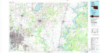
~ Tulsa OK topo map, 1:100000 scale, 30 X 60 Minute, Historical, 1985, updated 1985
Tulsa, Oklahoma, USGS topographic map dated 1985.
Includes geographic coordinates (latitude and longitude). This topographic map is suitable for hiking, camping, and exploring, or framing it as a wall map.
Printed on-demand using high resolution imagery, on heavy weight and acid free paper, or alternatively on a variety of synthetic materials.
Topos available on paper, Waterproof, Poly, or Tyvek. Usually shipping rolled, unless combined with other folded maps in one order.
- Product Number: USGS-5472799
- Free digital map download (high-resolution, GeoPDF): Tulsa, Oklahoma (file size: 21 MB)
- Map Size: please refer to the dimensions of the GeoPDF map above
- Weight (paper map): ca. 55 grams
- Map Type: POD USGS Topographic Map
- Map Series: HTMC
- Map Verison: Historical
- Cell ID: 68492
- Scan ID: 707170
- Imprint Year: 1985
- Woodland Tint: Yes
- Aerial Photo Year: 1980
- Edit Year: 1985
- Datum: NAD27
- Map Projection: Universal Transverse Mercator
- Planimetric: Yes
- Map published by United States Geological Survey
- Map Language: English
- Scanner Resolution: 508 dpi
- Map Cell Name: Tulsa
- Grid size: 30 X 60 Minute
- Date on map: 1985
- Map Scale: 1:100000
- Geographical region: Oklahoma, United States
Neighboring Maps:
All neighboring USGS topo maps are available for sale online at a variety of scales.
Spatial coverage:
Topo map Tulsa, Oklahoma, covers the geographical area associated the following places:
- Claremore - Disney - Mohawk - Sportsmen Acres - Tiger - Tulsa - Peggs - Degroat - Spavinaw - Iron Post - Bushyhead - New Tulsa - Edgewater Acres - Oowala - Sageeyah - Tiawah - Hisle - Patton - Valley Park - Sperry - Cedar Crest - Catoosa - Limestone - East Tulsa - Murphy - Oneta - Collinsville - Green - Fair Oaks - Yonkers - Gregory - Sequoyah - Rose - Keith - Jenks - Neodesha - Elba - Harmony Star - Inola - Salina - Osage Village (historical) - Garnett - Rocky Point - Paradise View - Justice - Owasso - Tip - Foyil - Chouteau - Lusta - Dawson - Pin Oak Acres - Verdigris - Boatman - Leliaetta - Locust Grove - Adair - Mingo - Broken Arrow - Oologah - Union - Pensacola - Sportsman Acres - Alsuma - Gideon - Pryor - Hoot Owl - Langley - Snake Creek - Keetonville - Douglas - Turley - Howard - Mazie - Ballou - McFarlin - Strang - Tia Juana - Vera - Lynn Lane
- Map Area ID: AREA36.536-96-95
- Northwest corner Lat/Long code: USGSNW36.5-96
- Northeast corner Lat/Long code: USGSNE36.5-95
- Southwest corner Lat/Long code: USGSSW36-96
- Southeast corner Lat/Long code: USGSSE36-95
- Northern map edge Latitude: 36.5
- Southern map edge Latitude: 36
- Western map edge Longitude: -96
- Eastern map edge Longitude: -95


