
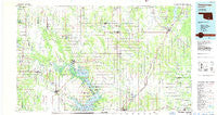
~ Tishomingo OK topo map, 1:100000 scale, 30 X 60 Minute, Historical, 1985, updated 1986
Tishomingo, Oklahoma, USGS topographic map dated 1985.
Includes geographic coordinates (latitude and longitude). This topographic map is suitable for hiking, camping, and exploring, or framing it as a wall map.
Printed on-demand using high resolution imagery, on heavy weight and acid free paper, or alternatively on a variety of synthetic materials.
Topos available on paper, Waterproof, Poly, or Tyvek. Usually shipping rolled, unless combined with other folded maps in one order.
- Product Number: USGS-5472793
- Free digital map download (high-resolution, GeoPDF): Tishomingo, Oklahoma (file size: 19 MB)
- Map Size: please refer to the dimensions of the GeoPDF map above
- Weight (paper map): ca. 55 grams
- Map Type: POD USGS Topographic Map
- Map Series: HTMC
- Map Verison: Historical
- Cell ID: 68463
- Scan ID: 707168
- Imprint Year: 1986
- Woodland Tint: Yes
- Aerial Photo Year: 1982
- Edit Year: 1985
- Datum: NAD27
- Map Projection: Universal Transverse Mercator
- Planimetric: Yes
- Map published by United States Geological Survey
- Map Language: English
- Scanner Resolution: 508 dpi
- Map Cell Name: Tishomingo
- Grid size: 30 X 60 Minute
- Date on map: 1985
- Map Scale: 1:100000
- Geographical region: Oklahoma, United States
Neighboring Maps:
All neighboring USGS topo maps are available for sale online at a variety of scales.
Spatial coverage:
Topo map Tishomingo, Oklahoma, covers the geographical area associated the following places:
- Stringtown - Ravia - Folsom - Troy - Durwood - Little City - Lehigh - McMillan - Caddo - Taloah - Emet - Bennington - Connerville - Bruno - Madill - Drake - Wasseta - Dickson - Cobb - Simpson - Milburn - Linn - Armstrong - Bromide - Bee - Silo - Earl - Antioch - Tishomingo - Tyler - Sevenmile Corner - Mill Creek - Oakland - Wapanucka - Russett - Atoka - Cumberland - Mannsville - Bromide Junction - Fort Washita - Nida - Matoy - Aylesworth - Banty - Pritchard - Olney - Robinson Corner - Fillmore - Ury - Reagan - Half Bank Crossing - Clarita - Coleman - Bokchito - Baum - Pontotoc - Kiersey - Wilson - Old Bennington - Nebo - Caney - Bentley - Eville - Hopewell - Tushka - Cook - Brown - Kenefic
- Map Area ID: AREA34.534-97-96
- Northwest corner Lat/Long code: USGSNW34.5-97
- Northeast corner Lat/Long code: USGSNE34.5-96
- Southwest corner Lat/Long code: USGSSW34-97
- Southeast corner Lat/Long code: USGSSE34-96
- Northern map edge Latitude: 34.5
- Southern map edge Latitude: 34
- Western map edge Longitude: -97
- Eastern map edge Longitude: -96


