
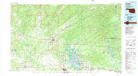
~ Antlers OK topo map, 1:100000 scale, 30 X 60 Minute, Historical, 1985, updated 1991
Antlers, Oklahoma, USGS topographic map dated 1985.
Includes geographic coordinates (latitude and longitude). This topographic map is suitable for hiking, camping, and exploring, or framing it as a wall map.
Printed on-demand using high resolution imagery, on heavy weight and acid free paper, or alternatively on a variety of synthetic materials.
Topos available on paper, Waterproof, Poly, or Tyvek. Usually shipping rolled, unless combined with other folded maps in one order.
- Product Number: USGS-5472713
- Free digital map download (high-resolution, GeoPDF): Antlers, Oklahoma (file size: 25 MB)
- Map Size: please refer to the dimensions of the GeoPDF map above
- Weight (paper map): ca. 55 grams
- Map Type: POD USGS Topographic Map
- Map Series: HTMC
- Map Verison: Historical
- Cell ID: 67057
- Scan ID: 707129
- Imprint Year: 1991
- Woodland Tint: Yes
- Aerial Photo Year: 1981
- Edit Year: 1985
- Datum: NAD27
- Map Projection: Universal Transverse Mercator
- Map published by United States Geological Survey
- Map Language: English
- Scanner Resolution: 508 dpi
- Map Cell Name: Antlers
- Grid size: 30 X 60 Minute
- Date on map: 1985
- Map Scale: 1:100000
- Geographical region: Oklahoma, United States
Neighboring Maps:
All neighboring USGS topo maps are available for sale online at a variety of scales.
Spatial coverage:
Topo map Antlers, Oklahoma, covers the geographical area associated the following places:
- Sobol - Messer - Belzoni - Apple - Dunbar - Big Rocks - Kellond - Alikchi - Wright City - Swink - Lane - Boehler - Pine Knot Crossing - Divide - Finley - Moyers - Nashoba Y - Felker - Boswell - Kosoma - Greenwood - Speer - Sunkist - Kent - Lone Pine - Forney - Wadena - Pickens - Unger - Corinne - Miller - Darwin - Burwell - Ringold - Antlers - Fort Towson - Negro Bend - Soper - Rattan - Oleta - Slim - Valliant - Mayhew - Sand Bluff - Rufe - Virgil - Jumbo - Doaksville (historical) - Nelson - Spencerville - Crystal - Hugo - Cade - Nashoba - Jasper - Hamden - West Fort Towson - Farris - Plainview - Ethel - Fugate - Dela - Mound Grove - Sawyer - Old Farris - Cloudy - Snow - Clebit - Eubanks - Payton Crossing - North Sobol - High Hill - Nolia
- Map Area ID: AREA34.534-96-95
- Northwest corner Lat/Long code: USGSNW34.5-96
- Northeast corner Lat/Long code: USGSNE34.5-95
- Southwest corner Lat/Long code: USGSSW34-96
- Southeast corner Lat/Long code: USGSSE34-95
- Northern map edge Latitude: 34.5
- Southern map edge Latitude: 34
- Western map edge Longitude: -96
- Eastern map edge Longitude: -95


