
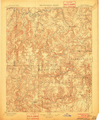
~ Marshall AR topo map, 1:125000 scale, 30 X 30 Minute, Historical, 1901
Marshall, Arkansas, USGS topographic map dated 1901.
Includes geographic coordinates (latitude and longitude). This topographic map is suitable for hiking, camping, and exploring, or framing it as a wall map.
Printed on-demand using high resolution imagery, on heavy weight and acid free paper, or alternatively on a variety of synthetic materials.
Topos available on paper, Waterproof, Poly, or Tyvek. Usually shipping rolled, unless combined with other folded maps in one order.
- Product Number: USGS-5429982
- Free digital map download (high-resolution, GeoPDF): Marshall, Arkansas (file size: 11 MB)
- Map Size: please refer to the dimensions of the GeoPDF map above
- Weight (paper map): ca. 55 grams
- Map Type: POD USGS Topographic Map
- Map Series: HTMC
- Map Verison: Historical
- Cell ID: 65996
- Scan ID: 260519
- Survey Year: 1889
- Datum: Unstated
- Map Projection: Unstated
- Map published by United States Geological Survey
- Map Language: English
- Scanner Resolution: 600 dpi
- Map Cell Name: Marshall
- Grid size: 30 X 30 Minute
- Date on map: 1901
- Map Scale: 1:125000
- Geographical region: Arkansas, United States
Neighboring Maps:
All neighboring USGS topo maps are available for sale online at a variety of scales.
Spatial coverage:
Topo map Marshall, Arkansas, covers the geographical area associated the following places:
- Cave Creek - Edge (historical) - Harriet - Williams Gulf (historical) - Kay - Koones Gulf (historical) - Austin - Gabriel (historical) - Rex - Walnut Grove - Pine Mountain (historical) - Culpepper - Jameson (historical) - Bohannon - Silver Hill - Begley (historical) - Blanco - Lebanon (historical) - Horn Mountain (historical) - Smyrna - Noahs - Buroak - Lost Corner - Ben Hur - Oak Flat (historical) - Magic Springs - Chimes - Snowball - Northwood (historical) - Welcome Home - Copeland - Watts - Raspberry - Crabtree - Okay (historical) - Wileys Cove - Alread - Marshall - Shilo (historical) - Zack - Retta - Rumley - Leigo (historical) - Barren Hollow - Baker - Dennard - Dry Creek (historical) - Rock Springs - Leslie - Marsena - Witts Springs - Tilly - Butter Creek (historical) - Gridley (historical) - Solo - Rupert - Morning Star - Booster - Botkinburg - Gilbert - Archey Valley - Latham (historical) - Ella (historical) - Imo - Dickey Junction - Buzzard Roost (historical) - Bass - Martin Box - Eula - Scotland - Point Peter - Slicker (historical) - Zeb (historical) - Racket Ridge (historical) - Woolum - Baker Hollow - Elberta - Dabney - Zion Hill - Moore - Nogo - Canaan - Flat - Rocky Hill - Lone Pine - Hall (historical) - Woolum - Gladys (historical) - Archey (historical) - Dongola - Bear Creek
- Map Area ID: AREA3635.5-93-92.5
- Northwest corner Lat/Long code: USGSNW36-93
- Northeast corner Lat/Long code: USGSNE36-92.5
- Southwest corner Lat/Long code: USGSSW35.5-93
- Southeast corner Lat/Long code: USGSSE35.5-92.5
- Northern map edge Latitude: 36
- Southern map edge Latitude: 35.5
- Western map edge Longitude: -93
- Eastern map edge Longitude: -92.5


