
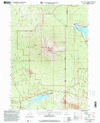
~ Mount Mc Loughlin OR topo map, 1:24000 scale, 7.5 X 7.5 Minute, Historical, 1998, updated 2000
Mount Mc Loughlin, Oregon, USGS topographic map dated 1998.
Includes geographic coordinates (latitude and longitude). This topographic map is suitable for hiking, camping, and exploring, or framing it as a wall map.
Printed on-demand using high resolution imagery, on heavy weight and acid free paper, or alternatively on a variety of synthetic materials.
Topos available on paper, Waterproof, Poly, or Tyvek. Usually shipping rolled, unless combined with other folded maps in one order.
- Product Number: USGS-5420340
- Free digital map download (high-resolution, GeoPDF): Mount Mc Loughlin, Oregon (file size: 13 MB)
- Map Size: please refer to the dimensions of the GeoPDF map above
- Weight (paper map): ca. 55 grams
- Map Type: POD USGS Topographic Map
- Map Series: HTMC
- Map Verison: Historical
- Cell ID: 30710
- Scan ID: 280824
- Imprint Year: 2000
- Woodland Tint: Yes
- Aerial Photo Year: 1994
- Edit Year: 1998
- Survey Year: 1983
- Datum: NAD27
- Map Projection: Lambert Conformal Conic
- Map published by United States Geological Survey
- Map published by United States Forest Service
- Map Language: English
- Scanner Resolution: 600 dpi
- Map Cell Name: Mount McLoughlin
- Grid size: 7.5 X 7.5 Minute
- Date on map: 1998
- Map Scale: 1:24000
- Geographical region: Oregon, United States
Neighboring Maps:
All neighboring USGS topo maps are available for sale online at a variety of scales.
Spatial coverage:
Topo map Mount Mc Loughlin, Oregon, covers the geographical area associated the following places:
- Squaw Lake - Cold Springs - Calamity Forest Camp (historical) - Fish Lake Resort Marina - Swan Creek - Fish Lake Recreation Site - Fish Lake - Summit Sno-Park - Twin Ponds Trail - North Fork Recreation Site - Camp Seventy-six - Bourbon Spring - Norris Pond - Rye Spring - Fish Lake Dam - South Squaw Tip - Freye Lake - Dry Creek Camp - Valley of the Rogue Dairy - Fish Lake Resort - Twin Ponds Camp - Rye Flat - Medford Watershed - High Lakes Pass - Crater Trail - Mirror Pond - Dogwood Spring - Mount McLoughlin Trail - Twin Ponds - Orris Pond - Doe Point Recreation Site - Mount McLoughlin - Squaw Tip Trail (historical) - Fourmile Lake - Blue Rock Trail - North Squaw Tip - Doe Point - Summit Lake
- Map Area ID: AREA42.542.375-122.375-122.25
- Northwest corner Lat/Long code: USGSNW42.5-122.375
- Northeast corner Lat/Long code: USGSNE42.5-122.25
- Southwest corner Lat/Long code: USGSSW42.375-122.375
- Southeast corner Lat/Long code: USGSSE42.375-122.25
- Northern map edge Latitude: 42.5
- Southern map edge Latitude: 42.375
- Western map edge Longitude: -122.375
- Eastern map edge Longitude: -122.25


