
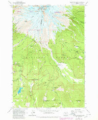
~ Mount Hood South OR topo map, 1:24000 scale, 7.5 X 7.5 Minute, Historical, 1962, updated 1980
Mount Hood South, Oregon, USGS topographic map dated 1962.
Includes geographic coordinates (latitude and longitude). This topographic map is suitable for hiking, camping, and exploring, or framing it as a wall map.
Printed on-demand using high resolution imagery, on heavy weight and acid free paper, or alternatively on a variety of synthetic materials.
Topos available on paper, Waterproof, Poly, or Tyvek. Usually shipping rolled, unless combined with other folded maps in one order.
- Product Number: USGS-5420328
- Free digital map download (high-resolution, GeoPDF): Mount Hood South, Oregon (file size: 13 MB)
- Map Size: please refer to the dimensions of the GeoPDF map above
- Weight (paper map): ca. 55 grams
- Map Type: POD USGS Topographic Map
- Map Series: HTMC
- Map Verison: Historical
- Cell ID: 30638
- Scan ID: 280818
- Imprint Year: 1980
- Woodland Tint: Yes
- Visual Version Number: 1
- Photo Revision Year: 1980
- Aerial Photo Year: 1973
- Edit Year: 1980
- Field Check Year: 1962
- Datum: NAD27
- Map Projection: Polyconic
- Map published by United States Geological Survey
- Map Language: English
- Scanner Resolution: 600 dpi
- Map Cell Name: Mount Hood South
- Grid size: 7.5 X 7.5 Minute
- Date on map: 1962
- Map Scale: 1:24000
- Geographical region: Oregon, United States
Neighboring Maps:
All neighboring USGS topo maps are available for sale online at a variety of scales.
Spatial coverage:
Topo map Mount Hood South, Oregon, covers the geographical area associated the following places:
- Mineral Creek - Alpine Ski Trail - Palmer Glacier - Bennett Pass - Newton Clark Glacier - Mount Hood - White River Park Campground - Buzzard Point - The Chimney - Sahale Falls - Umbrella Falls - Hood River Meadows - Trillium Lake Boat Ramp - Mississippi Head - Leuthold Couloir - Devils Half Acre Meadow Recreation Site - Gnarl Ridge Trail - Illumination Rock - Teacup Lake - Silcox Hut - Alpine Recreation Site - Bird Butte - Phlox Point Recreation Site - Reid Glacier - Paradise Park Shelter - West Fork Salmon River - Pucci Glade - Mount Hood Meadows Oregon Wastewater Treatment Plant - Switchback Falls - South Fork Mineral Creek - North Fork Mineral Creek - Lamberson Butte - Swim (historical) - Coalman Glacier - Triangle Moraine - Red Top Meadow - Barlow Butte - Still Creek Recreation Site - Steel Cliff - Hawkins Ridge - Mono Creek - Green Apple Creek - Mount Hood Wilderness - Zigzag Glacier - White River Glacier - Crater Rock - Palmateer Meadows - Pioneer Woman's Grave - Mitchell Creek - Barlow Ridge - Mount Hood Meadows Ski Resort - Palmateer Creek - Salmon River Campground - Swim Post Office (historical) - Devils Kitchen - Barlow Pass - Mud Creek Quarry - Summit Ranger Station - Government Camp Safety Rest Area - Trillium Lake Dam - Nanitch Campground - Snow Bunny Lodge - Swim Creek - Trillium Lake Recreation Site - Summit Meadows - East Fork Salmon River - White River Sand Pit - Hot Rocks - Trillium Lake - Camp Blossom - Devils Half Acre Meadow - North Fork Iron Creek - Umbrella Falls Trail - Timberline Lodge Post Office - Glade Ski Trail - Summit Meadows Cemetery - Gnarl Ridge - Timberline Lodge - South Fork Iron Creek - Barlow Guard Station - Timberline Post Office (historical)
- Map Area ID: AREA45.37545.25-121.75-121.625
- Northwest corner Lat/Long code: USGSNW45.375-121.75
- Northeast corner Lat/Long code: USGSNE45.375-121.625
- Southwest corner Lat/Long code: USGSSW45.25-121.75
- Southeast corner Lat/Long code: USGSSE45.25-121.625
- Northern map edge Latitude: 45.375
- Southern map edge Latitude: 45.25
- Western map edge Longitude: -121.75
- Eastern map edge Longitude: -121.625


