
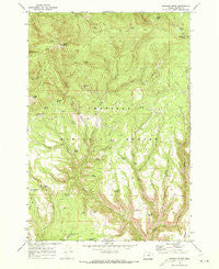
~ Madison Butte OR topo map, 1:24000 scale, 7.5 X 7.5 Minute, Historical, 1969, updated 1973
Madison Butte, Oregon, USGS topographic map dated 1969.
Includes geographic coordinates (latitude and longitude). This topographic map is suitable for hiking, camping, and exploring, or framing it as a wall map.
Printed on-demand using high resolution imagery, on heavy weight and acid free paper, or alternatively on a variety of synthetic materials.
Topos available on paper, Waterproof, Poly, or Tyvek. Usually shipping rolled, unless combined with other folded maps in one order.
- Product Number: USGS-5419908
- Free digital map download (high-resolution, GeoPDF): Madison Butte, Oregon (file size: 15 MB)
- Map Size: please refer to the dimensions of the GeoPDF map above
- Weight (paper map): ca. 55 grams
- Map Type: POD USGS Topographic Map
- Map Series: HTMC
- Map Verison: Historical
- Cell ID: 27184
- Scan ID: 280603
- Imprint Year: 1973
- Woodland Tint: Yes
- Aerial Photo Year: 1967
- Field Check Year: 1969
- Datum: NAD27
- Map Projection: Polyconic
- Map published by United States Geological Survey
- Map Language: English
- Scanner Resolution: 600 dpi
- Map Cell Name: Madison Butte
- Grid size: 7.5 X 7.5 Minute
- Date on map: 1969
- Map Scale: 1:24000
- Geographical region: Oregon, United States
Neighboring Maps:
All neighboring USGS topo maps are available for sale online at a variety of scales.
Spatial coverage:
Topo map Madison Butte, Oregon, covers the geographical area associated the following places:
- Bear Creek - Two Spring - Red Spring - Circle Bar Spring - Nine Top Camp - Bottle Spring - Red Hill - Hallock Spring - Little Bear Creek - Circle Bar Ranch - Tupper Spring - Wildcat Spring - New Deal Spring - Alder Creek - Cottonwood Spring - Tupper Guard Station - Skookum Spring - Grouse Spring - Brum Spring - Texas Butte - Hidden Spring - Madison Butte Trail - Wildcat Creek - H K Spring - Tupper Butte - Mud Spring - Arnica Spring - Nine Top Spring - Moreland Canyon - Madison Butte - Mahogany Flat - Skookum Game Exclosure - Midway Spring - Jug Spring - Bacon Spring - Two Spring Creek - Wire Corral Spring - Hog Creek - Lucky Spring - Copple Butte - Morphine Ranch - Camp Moreland Spring - East Fork Alder Creek - Sulphur Spring - Copple Butte Trail - Section Line Spring
- Map Area ID: AREA45.12545-119.5-119.375
- Northwest corner Lat/Long code: USGSNW45.125-119.5
- Northeast corner Lat/Long code: USGSNE45.125-119.375
- Southwest corner Lat/Long code: USGSSW45-119.5
- Southeast corner Lat/Long code: USGSSE45-119.375
- Northern map edge Latitude: 45.125
- Southern map edge Latitude: 45
- Western map edge Longitude: -119.5
- Eastern map edge Longitude: -119.375


