
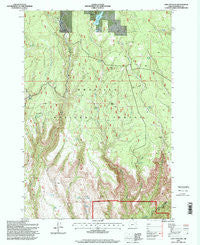
~ Lake Penland OR topo map, 1:24000 scale, 7.5 X 7.5 Minute, Historical, 1995, updated 1998
Lake Penland, Oregon, USGS topographic map dated 1995.
Includes geographic coordinates (latitude and longitude). This topographic map is suitable for hiking, camping, and exploring, or framing it as a wall map.
Printed on-demand using high resolution imagery, on heavy weight and acid free paper, or alternatively on a variety of synthetic materials.
Topos available on paper, Waterproof, Poly, or Tyvek. Usually shipping rolled, unless combined with other folded maps in one order.
- Product Number: USGS-5419538
- Free digital map download (high-resolution, GeoPDF): Lake Penland, Oregon (file size: 17 MB)
- Map Size: please refer to the dimensions of the GeoPDF map above
- Weight (paper map): ca. 55 grams
- Map Type: POD USGS Topographic Map
- Map Series: HTMC
- Map Verison: Historical
- Cell ID: 24613
- Scan ID: 280450
- Imprint Year: 1998
- Woodland Tint: Yes
- Aerial Photo Year: 1994
- Field Check Year: 1995
- Datum: NAD27
- Map Projection: Lambert Conformal Conic
- Map published by United States Geological Survey
- Map published by United States Forest Service
- Map Language: English
- Scanner Resolution: 600 dpi
- Map Cell Name: Lake Penland
- Grid size: 7.5 X 7.5 Minute
- Date on map: 1995
- Map Scale: 1:24000
- Geographical region: Oregon, United States
Neighboring Maps:
All neighboring USGS topo maps are available for sale online at a variety of scales.
Spatial coverage:
Topo map Lake Penland, Oregon, covers the geographical area associated the following places:
- Mallory Spring - Brown Prairie - Rock Spring - Ditch Creek Forest Sevice Station - Potato Hill - Thompson Corral - Yoyo Spring - Tepee Spring - Elkhorn Spring - Main Spring - Wickiup Creek - Cutsforth Dam - Little Potamus Creek - Martin Creek - Heck and Gone - Long Canyon - Lake Penland Dam - Groshen Cabin - Swale Spring - Brush Spring - Slop Spring - Deep Canyon Spring - Doghouse Spring - Cold Spring - Penland Lake Recreation Site - Wickiup Spring - McAttee Spring - Dry Swale Creek - Stalder Creek - Road Canyon - Butcher Bill Creek - Little Potamus Well - McMurdo Cabin - Penland Lake Boat Launch - Lake Penland
- Map Area ID: AREA45.12545-119.375-119.25
- Northwest corner Lat/Long code: USGSNW45.125-119.375
- Northeast corner Lat/Long code: USGSNE45.125-119.25
- Southwest corner Lat/Long code: USGSSW45-119.375
- Southeast corner Lat/Long code: USGSSE45-119.25
- Northern map edge Latitude: 45.125
- Southern map edge Latitude: 45
- Western map edge Longitude: -119.375
- Eastern map edge Longitude: -119.25


