
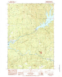
~ Green Peter OR topo map, 1:24000 scale, 7.5 X 7.5 Minute, Historical, 1984, updated 1985
Green Peter, Oregon, USGS topographic map dated 1984.
Includes geographic coordinates (latitude and longitude). This topographic map is suitable for hiking, camping, and exploring, or framing it as a wall map.
Printed on-demand using high resolution imagery, on heavy weight and acid free paper, or alternatively on a variety of synthetic materials.
Topos available on paper, Waterproof, Poly, or Tyvek. Usually shipping rolled, unless combined with other folded maps in one order.
- Product Number: USGS-5418826
- Free digital map download (high-resolution, GeoPDF): Green Peter, Oregon (file size: 15 MB)
- Map Size: please refer to the dimensions of the GeoPDF map above
- Weight (paper map): ca. 55 grams
- Map Type: POD USGS Topographic Map
- Map Series: HTMC
- Map Verison: Historical
- Cell ID: 18344
- Scan ID: 280097
- Imprint Year: 1985
- Woodland Tint: Yes
- Aerial Photo Year: 1980
- Edit Year: 1984
- Field Check Year: 1981
- Datum: NAD27
- Map Projection: Lambert Conformal Conic
- Provisional map: Yes
- Map published by United States Geological Survey
- Map Language: English
- Scanner Resolution: 600 dpi
- Map Cell Name: Green Peter
- Grid size: 7.5 X 7.5 Minute
- Date on map: 1984
- Map Scale: 1:24000
- Geographical region: Oregon, United States
Neighboring Maps:
All neighboring USGS topo maps are available for sale online at a variety of scales.
Spatial coverage:
Topo map Green Peter, Oregon, covers the geographical area associated the following places:
- Shot Pouch Butte - Spring Family Cemetery - Mouse Creek - Whisky Springs - Cascadia Census Designated Place - Green Peter Creek - Big Alder Creek - Hufford Bridge - Sunnyside County Park Marina - River Bend County Park Raft Access - Deadman Creek - Thistle Creek - South Fork McDowell Creek - Whitcomb Creek County Park Boat Ramp - Sunnyside County Park - Linn County - Whitcomb Creek County Park - Coal Creek - Thistle Creek County Park Boat Ramp - Quartzville Creek - Shot Pouch Creek - Lewis Creek County Park - Green Peter Dam - Thistle Creek County Park - River Bend County Park - Green Peter - Short Bridge - Whisky Butte - Sunnyside School (historical) - Bald Peter - Sunnyside County Park Boat Ramp - Menears Bend Campground - Calkins Park - Cascadia Ranger Station (historical) - Moss Butte - Mealey Post Office (historical) - Little Bottom Creek - Greenhorn Hill - Whitcomb Creek - Hughes Creek - Dundon Flat - Deer Creek - Rumbaugh Creek
- Map Area ID: AREA44.544.375-122.625-122.5
- Northwest corner Lat/Long code: USGSNW44.5-122.625
- Northeast corner Lat/Long code: USGSNE44.5-122.5
- Southwest corner Lat/Long code: USGSSW44.375-122.625
- Southeast corner Lat/Long code: USGSSE44.375-122.5
- Northern map edge Latitude: 44.5
- Southern map edge Latitude: 44.375
- Western map edge Longitude: -122.625
- Eastern map edge Longitude: -122.5


