
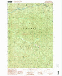
~ Cook Creek OR topo map, 1:24000 scale, 7.5 X 7.5 Minute, Historical, 1984, updated 1984
Cook Creek, Oregon, USGS topographic map dated 1984.
Includes geographic coordinates (latitude and longitude). This topographic map is suitable for hiking, camping, and exploring, or framing it as a wall map.
Printed on-demand using high resolution imagery, on heavy weight and acid free paper, or alternatively on a variety of synthetic materials.
Topos available on paper, Waterproof, Poly, or Tyvek. Usually shipping rolled, unless combined with other folded maps in one order.
- Product Number: USGS-5417504
- Free digital map download (high-resolution, GeoPDF): Cook Creek, Oregon (file size: 19 MB)
- Map Size: please refer to the dimensions of the GeoPDF map above
- Weight (paper map): ca. 55 grams
- Map Type: POD USGS Topographic Map
- Map Series: HTMC
- Map Verison: Historical
- Cell ID: 9933
- Scan ID: 279428
- Imprint Year: 1984
- Woodland Tint: Yes
- Visual Version Number: 2
- Aerial Photo Year: 1980
- Edit Year: 1984
- Field Check Year: 1982
- Datum: NAD27
- Map Projection: Lambert Conformal Conic
- Provisional map: Yes
- Map published by United States Geological Survey
- Map Language: English
- Scanner Resolution: 600 dpi
- Map Cell Name: Cook Creek
- Grid size: 7.5 X 7.5 Minute
- Date on map: 1984
- Map Scale: 1:24000
- Geographical region: Oregon, United States
Neighboring Maps:
All neighboring USGS topo maps are available for sale online at a variety of scales.
Spatial coverage:
Topo map Cook Creek, Oregon, covers the geographical area associated the following places:
- Hatchery Creek - High Butte - Triangulation Point - Water Tank (historical) - Rector - Helloff Post Office (historical) - Snark (historical) - Dry Creek - McKenny Creek - Bulck Canyon - Maples (historical) - Salmonberry (historical) - Wakefield (historical) - South Fork Cook Creek - French Creek - Snark Creek - Strahm Creek - McAboy (historical) - Wheeler Lumber Company (historical) - Clammer Creek - Rector Post Office (historical) - Helloff (historical) - Platt Canyon - Harliss Creek - Helloff Creek - Bastard Creek - Hoevet Creek - Haak Logging Company (historical) - Starr Creek - Buick (historical) - Hanson Creek - Sibley Creek - Nehalem Division - Salmonberry Post Office (historical) - Granite Creek - East Fork Cook Creek
- Map Area ID: AREA45.7545.625-123.75-123.625
- Northwest corner Lat/Long code: USGSNW45.75-123.75
- Northeast corner Lat/Long code: USGSNE45.75-123.625
- Southwest corner Lat/Long code: USGSSW45.625-123.75
- Southeast corner Lat/Long code: USGSSE45.625-123.625
- Northern map edge Latitude: 45.75
- Southern map edge Latitude: 45.625
- Western map edge Longitude: -123.75
- Eastern map edge Longitude: -123.625


