
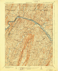
~ Hancock MD topo map, 1:62500 scale, 15 X 15 Minute, Historical, 1901, updated 1928
Hancock, Maryland, USGS topographic map dated 1901.
Includes geographic coordinates (latitude and longitude). This topographic map is suitable for hiking, camping, and exploring, or framing it as a wall map.
Printed on-demand using high resolution imagery, on heavy weight and acid free paper, or alternatively on a variety of synthetic materials.
Topos available on paper, Waterproof, Poly, or Tyvek. Usually shipping rolled, unless combined with other folded maps in one order.
- Product Number: USGS-5415390
- Free digital map download (high-resolution, GeoPDF): Hancock, Maryland (file size: 12 MB)
- Map Size: please refer to the dimensions of the GeoPDF map above
- Weight (paper map): ca. 55 grams
- Map Type: POD USGS Topographic Map
- Map Series: HTMC
- Map Verison: Historical
- Cell ID: 55035
- Scan ID: 253574
- Imprint Year: 1928
- Survey Year: 1899
- Datum: NAD
- Map Projection: Polyconic
- Map published by United States Geological Survey
- Map Language: English
- Scanner Resolution: 600 dpi
- Map Cell Name: Hancock
- Grid size: 15 X 15 Minute
- Date on map: 1901
- Map Scale: 1:62500
- Geographical region: Maryland, United States
Neighboring Maps:
All neighboring USGS topo maps are available for sale online at a variety of scales.
Spatial coverage:
Topo map Hancock, Maryland, covers the geographical area associated the following places:
- Dogtown - Elk Branch (historical) - Marvania Heights - Ridersville - Sir Johns Run - Yeakle Mill - Redrock Crossing - North Berkeley - Sleepy Creek - Johnsons Mill - Kirk Woods - Roundtop (historical) - Mount Trimble - Mann - Jimtown - Stanley - Golden Fleece Estates - Blue Hill - Baxter - Smith Crossroads - Fairview - Timber Ridge Heights - Holton - Johnsons Mill - Spohrs Crossroads - Big Pool - Mountain Vistas - Snyders - Ernstville - Park Head - Johnsontown - Myersdale - Shady Grove - Cohill Estates - Hancock - Burnt Factory - Indian Springs - Stotlers Crossroads - Pecktonville - Duckwall - Tomahawk - Berryville - New Hope - Myers (historical) - Berkeley Springs - Hancock - Cherry Run
- Map Area ID: AREA39.7539.5-78.25-78
- Northwest corner Lat/Long code: USGSNW39.75-78.25
- Northeast corner Lat/Long code: USGSNE39.75-78
- Southwest corner Lat/Long code: USGSSW39.5-78.25
- Southeast corner Lat/Long code: USGSSE39.5-78
- Northern map edge Latitude: 39.75
- Southern map edge Latitude: 39.5
- Western map edge Longitude: -78.25
- Eastern map edge Longitude: -78


