
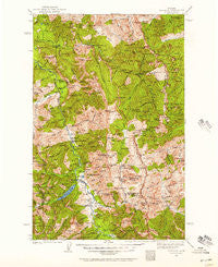
~ Silvertip MT topo map, 1:125000 scale, 30 X 30 Minute, Historical, 1936, updated 1957
Silvertip, Montana, USGS topographic map dated 1936.
Includes geographic coordinates (latitude and longitude). This topographic map is suitable for hiking, camping, and exploring, or framing it as a wall map.
Printed on-demand using high resolution imagery, on heavy weight and acid free paper, or alternatively on a variety of synthetic materials.
Topos available on paper, Waterproof, Poly, or Tyvek. Usually shipping rolled, unless combined with other folded maps in one order.
- Product Number: USGS-5401844
- Free digital map download (high-resolution, GeoPDF): Silvertip, Montana (file size: 14 MB)
- Map Size: please refer to the dimensions of the GeoPDF map above
- Weight (paper map): ca. 55 grams
- Map Type: POD USGS Topographic Map
- Map Series: HTMC
- Map Verison: Historical
- Cell ID: 66637
- Scan ID: 268617
- Imprint Year: 1957
- Woodland Tint: Yes
- Survey Year: 1936
- Datum: NAD27
- Map Projection: Polyconic
- Map published by United States Geological Survey
- Map Language: English
- Scanner Resolution: 600 dpi
- Map Cell Name: Silvertip
- Grid size: 30 X 30 Minute
- Date on map: 1936
- Map Scale: 1:125000
- Geographical region: Montana, United States
Neighboring Maps:
All neighboring USGS topo maps are available for sale online at a variety of scales.
Spatial coverage:
Topo map Silvertip, Montana, covers the geographical area associated the following places:
- Bent Creek - Hermit Lake - Scarface Peak - Chinese Wall Trail - Pine Creek - Jungle Creek - Beaver Creek Campground - Dean Ridge - Helen Creek - Oasis Pond - Murphy Flat - Brownie Creek - Argosy Creek - Packrat Mountain - White River Trail - Big Salmon Creek - Big Bill Mountain - Webb Lake - Lost Fork Ahorn Creek - Prairie Reef Lookout - Rock Creek Trail - Salt Mountain - Pedro Creek - Lewis Creek - Sergeant Creek - Beaver Creek - Burnt Creek - South Fork White River - Patrol Point - Hodag Creek - Picture Ridge - Spotted Bear Mountain Trail - Christopher Creek - Christopher Lake - Silvertip Mountain - Flame Peak - Una Creek - Big Salmon Lake - Straight Creek - North Fork Lick Creek - Turtlehead Mountain - Lime Creek - Cathedral Peak - Shadow Lake - Peggy Creek - Pagoda Creek - Chasm Creek - Pendant Guard Station - Garnet Creek - Minaret Peak - Moccasin Butte - Spotted Bear Lake - Pentagon Mountain - Prisoner Lake - Kevan Mountain - Signal Mountain - Cedar Creek - Gorge Creek - Seep Creek - Gunsight Trail - Brown Sandstone Peak - Shadow Mountain - Bunker Hill - Three Lakes Creek - Pentagon Guard Station - Bungalow Lookout Trail - Larch Hill - White River - Tillson Peak - Solitude Point - Hahn Peak - Holbrook Guard Station - Phil Creek - Meadow Creek Guard Station - White Ridge - Cliff Creek - Dean Falls - Rooney Creek - No Name Gulch - Charlotte Peak - Lake Levale - Black Bear Hump - White River Butte - White Bear Creek - Wall Creek Cliffs - Cliff Mountain - Slim Creek - Diamond Lake - Hammer Creek - Blue Lakes - Lamoose Creek - Clack Mountain - Three Sisters Creek - Burnt Creek - Cone Peak - Lewis and Clark Range - Hoop Creek - Spotted Bear Mountain - Hart Lake - Sarah Peak
- Map Area ID: AREA4847.5-113.5-113
- Northwest corner Lat/Long code: USGSNW48-113.5
- Northeast corner Lat/Long code: USGSNE48-113
- Southwest corner Lat/Long code: USGSSW47.5-113.5
- Southeast corner Lat/Long code: USGSSE47.5-113
- Northern map edge Latitude: 48
- Southern map edge Latitude: 47.5
- Western map edge Longitude: -113.5
- Eastern map edge Longitude: -113


