
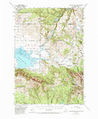
~ Upper Red Rock Lake MT topo map, 1:62500 scale, 15 X 15 Minute, Historical, 1950, updated 1973
Upper Red Rock Lake, Montana, USGS topographic map dated 1950.
Includes geographic coordinates (latitude and longitude). This topographic map is suitable for hiking, camping, and exploring, or framing it as a wall map.
Printed on-demand using high resolution imagery, on heavy weight and acid free paper, or alternatively on a variety of synthetic materials.
Topos available on paper, Waterproof, Poly, or Tyvek. Usually shipping rolled, unless combined with other folded maps in one order.
- Product Number: USGS-5401406
- Free digital map download (high-resolution, GeoPDF): Upper Red Rock Lake, Montana (file size: 12 MB)
- Map Size: please refer to the dimensions of the GeoPDF map above
- Weight (paper map): ca. 55 grams
- Map Type: POD USGS Topographic Map
- Map Series: HTMC
- Map Verison: Historical
- Cell ID: 63941
- Scan ID: 268326
- Imprint Year: 1973
- Woodland Tint: Yes
- Aerial Photo Year: 1947
- Field Check Year: 1950
- Datum: NAD27
- Map Projection: Polyconic
- Map published by United States Geological Survey
- Map Language: English
- Scanner Resolution: 600 dpi
- Map Cell Name: Upper Red Rock Lake
- Grid size: 15 X 15 Minute
- Date on map: 1950
- Map Scale: 1:62500
- Geographical region: Montana, United States
Neighboring Maps:
All neighboring USGS topo maps are available for sale online at a variety of scales.
Spatial coverage:
Topo map Upper Red Rock Lake, Montana, covers the geographical area associated the following places:
- Hidden Lake Camp Ground - Corral Creek - 14S01E24CDAA01 Well - Blind Creek Trail - 14S01E13BDA_01 Spring - 14S01E29DBAB01 Spring - Culver Springs Dam - Taylor Creek Trail - Elk Creek - Goose Lake - Deer Mountain - Blair Lake - Centennial Mountains - Nemesis Mountain - Taylor Mountain - Tin Cup Trail - 13S01E31DCAB01 Spring - Dry Creek Trail - 14S01E20CAB_01 Spring - Eastern Centennial Mountains - Hell Roaring Canyon - Twin Creek - 13S01W28BCBB01 Well - 14S01E23BCC_01 Spring - Culver Springs - Limestone Creek - Lobo Creek - 14S01E22ACBB01 Well - Sheridan Creek Trail - Hell Roaring Creek - Widgeon Pond Dam - 13S01W10BBA_01 Spring - Orr Ranch - Frog Spring (historical) - Myers Creek Trail - Lillian Lake - Red Rock Lakes National Wildlife Refuge - Cole Creek - Hidden Lake Bench - Swan Lake - 14S02E06CCCB01 Spring - 13S01E33AAC_01 Spring - Red Rock Mountain - Antelope Creek - Saddle Mountain - Elk Springs - Antelope Creek - Horse Creek - 13S01E36DDD_01 Spring - Widgeon Pond - Howard Creek Trail - 13S01W27BBAC01 Well - Red Rock Pass - Elk Lake Recreation Site - United States Sheep Experiment Station - Lone Tree Creek - Two Drink Springs - Tin Cup Creek - Snowshoe Pass - MacDonald Pond - 13S01W04DCC_01 Spring - Middle Fork Trail - 14S01E17BDB_01 Well - Willow Creek Trail - Shambow Pond - 13S01W28DDD_01 Well - 14S01E08DACC01 Spring - Cook Sheep Ranch - 14S01W21CDD_01 Spring - Hidden Lake - Selby Resort - West Fork Sheridan Creek - Hoodoo Pass - Battle Creek - Lost Mine Canyon - Taylor Mountain Mine - Horn Mountains - 13S01E29CAB_01 Spring - Brimstone Creek - Arrowhead Mountain - Conklin Lake - Snoo-weh Pass - Elk Mountain - Upper Red Rock Lake - 13S01W12DAAC01 Spring - Elk Lake - The Narrows - Narrows Creek - Middle Fork Sheridan Creek - Antelope Pond - Brays Butte - Alaska Basin - 14S02E07CBAD01 Spring - Poison Creek - Hackett Creek - Lone Tree Pass - Keg Spring - Horsemint Spring - Carrot Canyon - Reas Peak
- Map Area ID: AREA44.7544.5-111.75-111.5
- Northwest corner Lat/Long code: USGSNW44.75-111.75
- Northeast corner Lat/Long code: USGSNE44.75-111.5
- Southwest corner Lat/Long code: USGSSW44.5-111.75
- Southeast corner Lat/Long code: USGSSE44.5-111.5
- Northern map edge Latitude: 44.75
- Southern map edge Latitude: 44.5
- Western map edge Longitude: -111.75
- Eastern map edge Longitude: -111.5


