
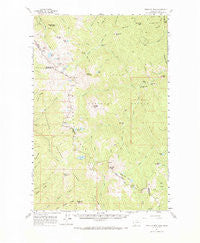
~ Straight Peak MT topo map, 1:62500 scale, 15 X 15 Minute, Historical, 1960, updated 1985
Straight Peak, Montana, USGS topographic map dated 1960.
Includes geographic coordinates (latitude and longitude). This topographic map is suitable for hiking, camping, and exploring, or framing it as a wall map.
Printed on-demand using high resolution imagery, on heavy weight and acid free paper, or alternatively on a variety of synthetic materials.
Topos available on paper, Waterproof, Poly, or Tyvek. Usually shipping rolled, unless combined with other folded maps in one order.
- Product Number: USGS-5401338
- Free digital map download (high-resolution, GeoPDF): Straight Peak, Montana (file size: 10 MB)
- Map Size: please refer to the dimensions of the GeoPDF map above
- Weight (paper map): ca. 55 grams
- Map Type: POD USGS Topographic Map
- Map Series: HTMC
- Map Verison: Historical
- Cell ID: 63025
- Scan ID: 268282
- Imprint Year: 1985
- Woodland Tint: Yes
- Aerial Photo Year: 1955
- Field Check Year: 1960
- Datum: NAD27
- Map Projection: Polyconic
- Map published by United States Geological Survey
- Map Language: English
- Scanner Resolution: 600 dpi
- Map Cell Name: Straight Peak
- Grid size: 15 X 15 Minute
- Date on map: 1960
- Map Scale: 1:62500
- Geographical region: Montana, United States
Neighboring Maps:
All neighboring USGS topo maps are available for sale online at a variety of scales.
Spatial coverage:
Topo map Straight Peak, Montana, covers the geographical area associated the following places:
- Straight Creek - Saint Patrick Peak - North Fork Cabin - Hells Thicket Creek - Foley Basin - Japanese Creek - Admiral Peak - North Fork Fish Creek - Heineman Ridge - Surveyor Lake - Trio Lakes - Fire Creek - Rivulet Peak - Straight Lake - West Fork Fish Creek - Irish Basin - Blacktail Creek - French Lake - Crater Lake - Bruin Hill - Siam Creek - Clear Water Crossing Ranger Station - Snowy Gulch - Wapito Point - Needle Point - Goose Lake - Clearwater Crossing Campground - Little Phoebe Mountain - West Fork Indian Creek - Buckos Pocket - Fish Lake - Snowshoe Mine - McMullan Peak - French Creek - Hidden Creek - Packers Gulch - Baileys Lodge - Cedar Log Creek - Lightning Peak - Kelly Lake - Siamese Lakes - Hole-in-the-Wall Ranch - Tanglefoot Creek - Cedar Peak - Greenwood Creek - Indian Creek Lodge - Greenwood Cabins - Indian Creek - Steep Creek - Chilcoot Pass - Kid Lake - Mud Lake - Crater Mountain - Straight Peak - Schley Mountain - Cedar Log Lakes - Dalton Lake - Whiterock Gulch - Steep Lakes - Crater Creek - Bruin Ridge - Pearl Lake - Schley Saddle - Wapito Creek - East Fork Indian Creek - Middle Fork Indian Creek - Heart Lake - Hidden Lake - Fletcher Gulch - Lake Creek
- Map Area ID: AREA4746.75-115-114.75
- Northwest corner Lat/Long code: USGSNW47-115
- Northeast corner Lat/Long code: USGSNE47-114.75
- Southwest corner Lat/Long code: USGSSW46.75-115
- Southeast corner Lat/Long code: USGSSE46.75-114.75
- Northern map edge Latitude: 47
- Southern map edge Latitude: 46.75
- Western map edge Longitude: -115
- Eastern map edge Longitude: -114.75


