
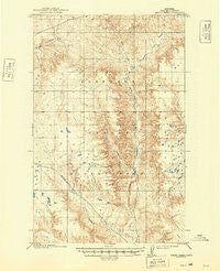
~ Spring Creek MT topo map, 1:62500 scale, 15 X 15 Minute, Historical, 1915, updated 1949
Spring Creek, Montana, USGS topographic map dated 1915.
Includes geographic coordinates (latitude and longitude). This topographic map is suitable for hiking, camping, and exploring, or framing it as a wall map.
Printed on-demand using high resolution imagery, on heavy weight and acid free paper, or alternatively on a variety of synthetic materials.
Topos available on paper, Waterproof, Poly, or Tyvek. Usually shipping rolled, unless combined with other folded maps in one order.
- Product Number: USGS-5401320
- Free digital map download (high-resolution, GeoPDF): Spring Creek, Montana (file size: 9 MB)
- Map Size: please refer to the dimensions of the GeoPDF map above
- Weight (paper map): ca. 55 grams
- Map Type: POD USGS Topographic Map
- Map Series: HTMC
- Map Verison: Historical
- Cell ID: 62863
- Scan ID: 268271
- Imprint Year: 1949
- Survey Year: 1910
- Datum: Unstated
- Map Projection: Polyconic
- Map published by United States Geological Survey
- Map Language: English
- Scanner Resolution: 600 dpi
- Map Cell Name: Spring Creek
- Grid size: 15 X 15 Minute
- Date on map: 1915
- Map Scale: 1:62500
- Geographical region: Montana, United States
Neighboring Maps:
All neighboring USGS topo maps are available for sale online at a variety of scales.
Spatial coverage:
Topo map Spring Creek, Montana, covers the geographical area associated the following places:
- Olfert Airport - 29N44E09ACDC01 Well - O'Watch Coulee - Star School (historical) - 31N43E29BCCD01 Well - 29N44E16DDDC01 Well - 30N42E01CDBC01 Well - 31N44E33DABA01 Well - Pleasant Valley School (historical) - 31N43E20CDDD01 Well - 30N44E07DDD_01 Well - 31N42E25ABCB01 Well - Fort Peck Reservation Division - 31N43E30DCAB01 Well - 31N43E20CDDD02 Well - Ghost Number 3 Dam - Jack Norris Coulee - 30N44E09CBAB01 Well - West Fork Little Porcupine Creek - Neufeld Coulee - 29N44E09ACDD01 Well - Spring Valley School (historical) - 31N43E29BCCB01 Well - Tomato Can Creek - Grain Post Office (historical) - Spring Valley - 30N42E02DDBB01 Well - 31N44E28AAAB01 Well - East Fork Little Porcupine Creek - Spring Creek - Harding School (historical) - 31N44E17DDAA01 Well - 31N44E28AAAC01 Well - Frazier District - 30N44E28DCDB01 Well - 31N44E33DADA01 Well - Hauck Coulee - 31N43E20CDDC01 Well - 30N44E20ACBA01 Well - 31N44E20BDBD01 Well - 31N44E04AAAC01 Well - Gold Medal Post Office (historical)
- Map Area ID: AREA48.548.25-106.25-106
- Northwest corner Lat/Long code: USGSNW48.5-106.25
- Northeast corner Lat/Long code: USGSNE48.5-106
- Southwest corner Lat/Long code: USGSSW48.25-106.25
- Southeast corner Lat/Long code: USGSSE48.25-106
- Northern map edge Latitude: 48.5
- Southern map edge Latitude: 48.25
- Western map edge Longitude: -106.25
- Eastern map edge Longitude: -106


