
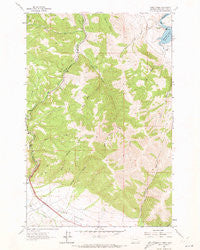
~ Sheep Creek MT topo map, 1:24000 scale, 7.5 X 7.5 Minute, Historical, 1962, updated 1973
Sheep Creek, Montana, USGS topographic map dated 1962.
Includes geographic coordinates (latitude and longitude). This topographic map is suitable for hiking, camping, and exploring, or framing it as a wall map.
Printed on-demand using high resolution imagery, on heavy weight and acid free paper, or alternatively on a variety of synthetic materials.
Topos available on paper, Waterproof, Poly, or Tyvek. Usually shipping rolled, unless combined with other folded maps in one order.
- Product Number: USGS-5398670
- Free digital map download (high-resolution, GeoPDF): Sheep Creek, Montana (file size: 13 MB)
- Map Size: please refer to the dimensions of the GeoPDF map above
- Weight (paper map): ca. 55 grams
- Map Type: POD USGS Topographic Map
- Map Series: HTMC
- Map Verison: Historical
- Cell ID: 40868
- Scan ID: 266642
- Imprint Year: 1973
- Woodland Tint: Yes
- Aerial Photo Year: 1956
- Field Check Year: 1962
- Datum: NAD27
- Map Projection: Polyconic
- Map published by United States Geological Survey
- Map Language: English
- Scanner Resolution: 600 dpi
- Map Cell Name: Sheep Creek
- Grid size: 7.5 X 7.5 Minute
- Date on map: 1962
- Map Scale: 1:24000
- Geographical region: Montana, United States
Neighboring Maps:
All neighboring USGS topo maps are available for sale online at a variety of scales.
Spatial coverage:
Topo map Sheep Creek, Montana, covers the geographical area associated the following places:
- Interchange 219 - Wolf Creek Quarry (historical) - West Sheep Creek - Lichen Cliff Fishing Access Site - Rose Gulch - SW NW Section 14 Mine - Lyons Creek Rest Area - Wood Siding (historical) - Holter Post Office (historical) - SE SE Section 4 Mine - Levings Gulch - Middle Fork Little Creek - Table Rock Fishing Access Site - Manila (historical) - Oxbow Landing Strip (historical) - Interchange 216 - Prickly Pear Fishing Access Site - Sieben Ranch - Bear Gulch - Sheep Creek - Sheep Creek Bridge - Main Fork Little Creek - Wolf Creek Gaging Station - Oxbow Ranch - North Fork Little Creek - Central Montana Railroad Historical Marker - Clark Creek - Sheep Creek Mine - SE NE Section 10 Mine - Little Creek - Spring Gulch - Gleason (historical) - Holter Dam
- Map Area ID: AREA4746.875-112.125-112
- Northwest corner Lat/Long code: USGSNW47-112.125
- Northeast corner Lat/Long code: USGSNE47-112
- Southwest corner Lat/Long code: USGSSW46.875-112.125
- Southeast corner Lat/Long code: USGSSE46.875-112
- Northern map edge Latitude: 47
- Southern map edge Latitude: 46.875
- Western map edge Longitude: -112.125
- Eastern map edge Longitude: -112


