
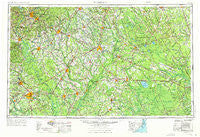
~ Florence SC topo map, 1:250000 scale, 1 X 2 Degree, Historical, 1953, updated 1976
Florence, South Carolina, USGS topographic map dated 1953.
Includes geographic coordinates (latitude and longitude). This topographic map is suitable for hiking, camping, and exploring, or framing it as a wall map.
Printed on-demand using high resolution imagery, on heavy weight and acid free paper, or alternatively on a variety of synthetic materials.
Topos available on paper, Waterproof, Poly, or Tyvek. Usually shipping rolled, unless combined with other folded maps in one order.
- Product Number: USGS-5389138
- Free digital map download (high-resolution, GeoPDF): Florence, South Carolina (file size: 21 MB)
- Map Size: please refer to the dimensions of the GeoPDF map above
- Weight (paper map): ca. 55 grams
- Map Type: POD USGS Topographic Map
- Map Series: HTMC
- Map Verison: Historical
- Cell ID: 68780
- Scan ID: 262040
- Imprint Year: 1976
- Woodland Tint: Yes
- Aerial Photo Year: 1973
- Edit Year: 1974
- Field Check Year: 1953
- Datum: Unstated
- Map Projection: Transverse Mercator
- Map published by United States Geological Survey
- Map Language: English
- Scanner Resolution: 600 dpi
- Map Cell Name: Florence
- Grid size: 1 X 2 Degree
- Date on map: 1953
- Map Scale: 1:250000
- Geographical region: South Carolina, United States
Neighboring Maps:
All neighboring USGS topo maps are available for sale online at a variety of scales.
Spatial coverage:
Topo map Florence, South Carolina, covers the geographical area associated the following places:
- Camelin Acres - Hickory Grove - Diggs - Arrowood - Clinton - Enchanted Meadows - Bell Swamp - Stewartville Acres - Ash - Town and Country Estates - Ida Mill - Oak Grove - Cairo - Sandyfield - Country Manor - Meadow Brook - Cognac - Bunker Hill - Polecat Landing - Fruitland - Highsmiths - Riverview - Brices Crossroads - Crump Town - Pine Village - Freeland - Pine Grove - Five Forks - Gibbs Crossroads - Sunset Acres - McDonald - Quinby Forest - Ricefield - Centerville - Kings Grant - Funston - New Life - Long Branch - Williams - Needmore - Pitch Landing - Whispering Pines Number Two - Country Club Mobile Home Park - Ketchuptown - Foxcroft - Prosper - South Park - Century Acres - Fairfax Heights - Magnolia - Eastover Estates - Pates - Wallace - Claussen - Five Points - Ariel Cross Road - Rockingham - Cypress Creek - Middle River - Berrys Crossroads - Briarcliff - Madeline - Boykin - McInnis (historical) - Nichols - Ivanhoe - Howe - Ponderosa - Howellsville - Turner Place - Smiths - Old Sneedsboro - Country Side Mobile Home Park - Hoffmeyer Crossroads - Concord - Chavistown - Live Oak - Grace Heights - Newtons Crossroads - Evergreen - Welsh Neck (historical) - Village Green - Five Forks - Pinet Knoll - Barb Crest Trailer Park - Kingdale - Smith Crossroads - Yorick - Dulah - Thompsons (historical) - Emerson - Pine Forest Plantation - Tobermory - Teachey - Westbrook - Davis Landing - Dubose Crossroads - Clifton Forge - Carvers - Snowhill
- Map Area ID: AREA3534-80-78
- Northwest corner Lat/Long code: USGSNW35-80
- Northeast corner Lat/Long code: USGSNE35-78
- Southwest corner Lat/Long code: USGSSW34-80
- Southeast corner Lat/Long code: USGSSE34-78
- Northern map edge Latitude: 35
- Southern map edge Latitude: 34
- Western map edge Longitude: -80
- Eastern map edge Longitude: -78


