
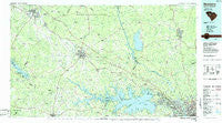
~ Newberry SC topo map, 1:100000 scale, 30 X 60 Minute, Historical, 1986, updated 1986
Newberry, South Carolina, USGS topographic map dated 1986.
Includes geographic coordinates (latitude and longitude). This topographic map is suitable for hiking, camping, and exploring, or framing it as a wall map.
Printed on-demand using high resolution imagery, on heavy weight and acid free paper, or alternatively on a variety of synthetic materials.
Topos available on paper, Waterproof, Poly, or Tyvek. Usually shipping rolled, unless combined with other folded maps in one order.
- Product Number: USGS-5389086
- Free digital map download (high-resolution, GeoPDF): Newberry, South Carolina (file size: 24 MB)
- Map Size: please refer to the dimensions of the GeoPDF map above
- Weight (paper map): ca. 55 grams
- Map Type: POD USGS Topographic Map
- Map Series: HTMC
- Map Verison: Historical
- Cell ID: 68052
- Scan ID: 262013
- Imprint Year: 1986
- Woodland Tint: Yes
- Aerial Photo Year: 1984
- Edit Year: 1986
- Datum: NAD27
- Map Projection: Universal Transverse Mercator
- Planimetric: Yes
- Map published by United States Geological Survey
- Map Language: English
- Scanner Resolution: 600 dpi
- Map Cell Name: Newberry
- Grid size: 30 X 60 Minute
- Date on map: 1986
- Map Scale: 1:100000
- Geographical region: South Carolina, United States
Neighboring Maps:
All neighboring USGS topo maps are available for sale online at a variety of scales.
Spatial coverage:
Topo map Newberry, South Carolina, covers the geographical area associated the following places:
- Bleases Crossroads - Frost - Monticello - Hyatts - Black Gate - Mandel Park - Kibler - Gilliam Spring (historical) - Southeast Newberry - Coatesworth - Saint Andrews - Mudlick - Big Creek - Saluda Gardens - Elmwood - East Lake - West Chester - Spring Grove (historical) - Varnarsdale - Helena - Raintree Acres - Simpson - Cross Roads - Jug Hole - Ella - Riverside Forest - Challedon West - Woodland Hills - Cromer Crossroads - Byrneswood - Ballentine - White Oak - Boland Crossroads (historical) - Montgomery - Broad River Estates - Living Inn - White Plains Crossroad - Lost Creek - Neighbors Crossroads - Oldtown (historical) - Friarsgate - Latimer Manor - Smallwood - Bachman Chapel - Winnsboro Mills - Shelton - Vaughanville - Renno - Shadow Brook - Boyd - North Twenty One Terrace - Wheeland - White Rock - Irmo - Pomaria - Chartwell - Clayton - Green Acres - Lowmans Crossroads (historical) - Dutchbrook - Barhamville Estates - Climax - Grenadier - The Forest - Colonial Heights - Blair - Park Place West - Clinton - Hickory Grove - Walton (historical) - Landmark - Baronywood - Riverbanks - Mountville - Garlington (historical) - Peters - Highland Forest - Taylors Crossroads - Oswald Park - Bonnie Forest - Spring Lake - Douglass - Old Buckhead - Melrose Heights - Eison Crossroads - Emerald Valley - Hollywood Point - Greenwood Shores - Selwood Shores - Littleton - Waverly - Rion - Longshore - Bonds Crossroads - Mallard Bay - Kingswood - Kinards - Mount Willing - Pleasant (historical) - Dutch Square
- Map Area ID: AREA34.534-82-81
- Northwest corner Lat/Long code: USGSNW34.5-82
- Northeast corner Lat/Long code: USGSNE34.5-81
- Southwest corner Lat/Long code: USGSSW34-82
- Southeast corner Lat/Long code: USGSSE34-81
- Northern map edge Latitude: 34.5
- Southern map edge Latitude: 34
- Western map edge Longitude: -82
- Eastern map edge Longitude: -81


