
~ Beaufort SC topo map, 1:100000 scale, 30 X 60 Minute, Historical, 1978, updated 1978
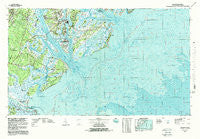
Beaufort, South Carolina, USGS topographic map dated 1978.
Includes geographic coordinates (latitude and longitude). This topographic map is suitable for hiking, camping, and exploring, or framing it as a wall map.
Printed on-demand using high resolution imagery, on heavy weight and acid free paper, or alternatively on a variety of synthetic materials.
Topos available on paper, Waterproof, Poly, or Tyvek. Usually shipping rolled, unless combined with other folded maps in one order.
- Product Number: USGS-5389054
- Free digital map download (high-resolution, GeoPDF): Beaufort, South Carolina (file size: 38 MB)
- Map Size: please refer to the dimensions of the GeoPDF map above
- Weight (paper map): ca. 55 grams
- Map Type: POD USGS Topographic Map
- Map Series: HTMC
- Map Verison: Historical
- Cell ID: 67113
- Scan ID: 261997
- Imprint Year: 1978
- Woodland Tint: Yes
- Visual Version Number: 2
- Aerial Photo Year: 1974
- Edit Year: 1978
- Datum: NAD27
- Map Projection: Universal Transverse Mercator
- Map published by United States Geological Survey
- Map Language: English
- Scanner Resolution: 600 dpi
- Map Cell Name: Beaufort
- Grid size: 30 X 60 Minute
- Date on map: 1978
- Map Scale: 1:100000
- Geographical region: South Carolina, United States
Neighboring Maps:
All neighboring USGS topo maps are available for sale online at a variety of scales.
Spatial coverage:
Topo map Beaufort, South Carolina, covers the geographical area associated the following places:
- Point Comfort - River Reach - Grays Hill - Salvesbarg Landing - Good Hope Landing - Red Oak - Fripp Landing - Fairway Oaks - Hilton Head Island - Tybee Island - Marsh Hawk - Port Royal Plantation - Red Bluff Estates - Indigo Run - Cooper River Landing - Walsh - Partridge Woods - Shipyard Plantation - Cedar Reef Villas - Quail Run - Bluff Farm - Bryan Landing - Daufuskie Landing - Sea Pines Circle - Windmill Harbor - Quail Ridge - Myrtle Island - Longwood - Copp Landing - Bon Aire - Sherwood Forest - Woodridge Estates - Boyd - Attaway - Honey Horn Plantation - Royal Pines Country Club Estates - Buckingham Landing - Country Club Bluff - Peace Haven - Calibogue Cay - Orange Grove - Santa Elena (historical) - Seabrook Landing - Wilmington Island - Hickory Bluff - Port Royal Landing - Walling Grove - Oceanmarsh Subdivision - Daniels - River Oaks - Scott - Frogmore - Rivers Edge - Opossum Point Landing - Pinckney Colony - Springfield - Shelter Cove - Murad - Burton - White Oaks - Cherry Hill Estates - Wilkins - Forest Fields - Oakwood Park - South Sea Pines - Palmetto Dunes - Okatie - Pleasant Point - Polk Village - Bay Pines - Fort Screven - Mink Point Plantation - Spanish Wells - Otter Hole - Bram Landing - Jasper - Battery Marina Village - Greenwood Forest - Green Pond - Blue Heron Bluff - Brighton Beach - Academy Estates - Wexford Plantation - Lucy Creek - Lawton - Chesterfield - Gator Field - Ashdale - Hilton Head Plantation - Sangster Village - Palmetto Estates - Walnut Hill - Barrell Landing - Nevadum - Fort Fremont - James Byrnes Estates - Laurel Bay - Capehart Housing Project - Grasslawn Beach - Nautical Watch Villas
- Map Area ID: AREA32.532-81-80
- Northwest corner Lat/Long code: USGSNW32.5-81
- Northeast corner Lat/Long code: USGSNE32.5-80
- Southwest corner Lat/Long code: USGSSW32-81
- Southeast corner Lat/Long code: USGSSE32-80
- Northern map edge Latitude: 32.5
- Southern map edge Latitude: 32
- Western map edge Longitude: -81
- Eastern map edge Longitude: -80


