
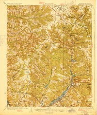
~ Warrenville SC topo map, 1:62500 scale, 15 X 15 Minute, Historical, 1928
Warrenville, South Carolina, USGS topographic map dated 1928.
Includes geographic coordinates (latitude and longitude). This topographic map is suitable for hiking, camping, and exploring, or framing it as a wall map.
Printed on-demand using high resolution imagery, on heavy weight and acid free paper, or alternatively on a variety of synthetic materials.
Topos available on paper, Waterproof, Poly, or Tyvek. Usually shipping rolled, unless combined with other folded maps in one order.
- Product Number: USGS-5389014
- Free digital map download (high-resolution, GeoPDF): Warrenville, South Carolina (file size: 10 MB)
- Map Size: please refer to the dimensions of the GeoPDF map above
- Weight (paper map): ca. 55 grams
- Map Type: POD USGS Topographic Map
- Map Series: HTMC
- Map Verison: Historical
- Cell ID: 64250
- Scan ID: 261977
- Woodland Tint: Yes
- Survey Year: 1923
- Datum: NAD
- Map Projection: Polyconic
- Map published by United States Army Corps of Engineers
- Map published by United States Department of War
- Map Language: English
- Scanner Resolution: 600 dpi
- Map Cell Name: Warrenville
- Grid size: 15 X 15 Minute
- Date on map: 1928
- Map Scale: 1:62500
- Geographical region: South Carolina, United States
Neighboring Maps:
All neighboring USGS topo maps are available for sale online at a variety of scales.
Spatial coverage:
Topo map Warrenville, South Carolina, covers the geographical area associated the following places:
- Belvedere - Rainbow Falls - Laurel Lakes - Edgefield Heights - Stiefeltown - Rose Hill - Martintowne - Crestdale - Midland Valley - Mixville - Windtree - Brookgreen - Springdale - Shannon - Burnettown - Ropers Crossroads - Pinehurst - Country Place - Ridgecrest - Trenton - Foxchase - Hammond Hills - Warrenville - Bahama Heights - Heathwood Park - The Colony - Greenfield - Lake Forest Estates - Westcliff - Fairview Gardens - Heatherwood - Rennie (historical) - Kalmia Hills - Coventry - Audubon Homes - Crestland - Murphys Estates - Wellington - Milledgeville (historical) - Pinecrest - Willow Springs Park - Pineview Acres - Bath - Lakewood - Langley Villa - Carolina Terrace - Barclay Estates - Highview (historical) - Crafton (historical) - Langley - Smithfield - Gregg Park - Woodlawn - Aiken Heights - Madison - Vaucluse - Southwood - Briarcliff - Deerwood - Lynnhurst - Ascaga Heights - Eureka - Bradleyville - Graniteville - Sandlewood - Belclear - Bonnie Glen - Gloverville - Woodridge - North Augusta - Horse Creek - Pinewood Plantation - Kalmia Landing - Sweetwater - Sunny Brook - Pineview Estates - Rotalata - Baynham (historical) - Pine and Oak Woods - Augusta View Heights - Summer Hill - Huntington Estates - Lynwood - Wise (historical) - Jacksonville - Huntcliff - Pine House Crossroads - Big Cone Ridge - Lakewood - Swearingen (historical) - Brierfield - Pine Valley - Brogden
- Map Area ID: AREA33.7533.5-82-81.75
- Northwest corner Lat/Long code: USGSNW33.75-82
- Northeast corner Lat/Long code: USGSNE33.75-81.75
- Southwest corner Lat/Long code: USGSSW33.5-82
- Southeast corner Lat/Long code: USGSSE33.5-81.75
- Northern map edge Latitude: 33.75
- Southern map edge Latitude: 33.5
- Western map edge Longitude: -82
- Eastern map edge Longitude: -81.75


