
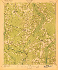
~ Ridgeville SC topo map, 1:62500 scale, 15 X 15 Minute, Historical, 1920
Ridgeville, South Carolina, USGS topographic map dated 1920.
Includes geographic coordinates (latitude and longitude). This topographic map is suitable for hiking, camping, and exploring, or framing it as a wall map.
Printed on-demand using high resolution imagery, on heavy weight and acid free paper, or alternatively on a variety of synthetic materials.
Topos available on paper, Waterproof, Poly, or Tyvek. Usually shipping rolled, unless combined with other folded maps in one order.
- Product Number: USGS-5388918
- Free digital map download (high-resolution, GeoPDF): Ridgeville, South Carolina (file size: 7 MB)
- Map Size: please refer to the dimensions of the GeoPDF map above
- Weight (paper map): ca. 55 grams
- Map Type: POD USGS Topographic Map
- Map Series: HTMC
- Map Verison: Historical
- Cell ID: 61616
- Scan ID: 261926
- Woodland Tint: Yes
- Survey Year: 1918
- Datum: Unstated
- Map Projection: Unstated
- Map published by United States Army Corps of Engineers
- Map published by United States Department of War
- Map Language: English
- Scanner Resolution: 600 dpi
- Map Cell Name: Ridgeville
- Grid size: 15 X 15 Minute
- Date on map: 1920
- Map Scale: 1:62500
- Geographical region: South Carolina, United States
Neighboring Maps:
All neighboring USGS topo maps are available for sale online at a variety of scales.
Spatial coverage:
Topo map Ridgeville, South Carolina, covers the geographical area associated the following places:
- Inabinetts (historical) - Mount Pisgah - Pregnall - Laurence (historical) - Scotch Range Estates - Givhans - Giant - Mas Old Field Landing - Hope (historical) - Lincoln Green - Summerset Acres - Pringletown - Harleyville - Dorchester - Ridgeville - Russell Lake Landing - Holly Ridge - Spring Hill - Twin Lakes
- Map Area ID: AREA33.2533-80.5-80.25
- Northwest corner Lat/Long code: USGSNW33.25-80.5
- Northeast corner Lat/Long code: USGSNE33.25-80.25
- Southwest corner Lat/Long code: USGSSW33-80.5
- Southeast corner Lat/Long code: USGSSE33-80.25
- Northern map edge Latitude: 33.25
- Southern map edge Latitude: 33
- Western map edge Longitude: -80.5
- Eastern map edge Longitude: -80.25


