
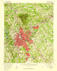
~ Greenville SC topo map, 1:62500 scale, 15 X 15 Minute, Historical, 1957, updated 1959
Greenville, South Carolina, USGS topographic map dated 1957.
Includes geographic coordinates (latitude and longitude). This topographic map is suitable for hiking, camping, and exploring, or framing it as a wall map.
Printed on-demand using high resolution imagery, on heavy weight and acid free paper, or alternatively on a variety of synthetic materials.
Topos available on paper, Waterproof, Poly, or Tyvek. Usually shipping rolled, unless combined with other folded maps in one order.
- Product Number: USGS-5388786
- Free digital map download (high-resolution, GeoPDF): Greenville, South Carolina (file size: 11 MB)
- Map Size: please refer to the dimensions of the GeoPDF map above
- Weight (paper map): ca. 55 grams
- Map Type: POD USGS Topographic Map
- Map Series: HTMC
- Map Verison: Historical
- Cell ID: 54846
- Scan ID: 261858
- Imprint Year: 1959
- Woodland Tint: Yes
- Aerial Photo Year: 1955
- Field Check Year: 1957
- Survey Year: 1935
- Datum: NAD27
- Map Projection: Polyconic
- Map published by United States Geological Survey
- Map Language: English
- Scanner Resolution: 600 dpi
- Map Cell Name: Greenville
- Grid size: 15 X 15 Minute
- Date on map: 1957
- Map Scale: 1:62500
- Geographical region: South Carolina, United States
Neighboring Maps:
All neighboring USGS topo maps are available for sale online at a variety of scales.
Spatial coverage:
Topo map Greenville, South Carolina, covers the geographical area associated the following places:
- Silver Leaf - Orchard Acres - Lockwood Heights - Oak Crest - Gower Estates - Berea Forest - South Forest Estates - Sans Souci Heights - Colonial Oaks Mobile Manor - Woodwinds - Sunset Forest - Terra Oaks - Little Texas - Cunningham Acres - Wade Hampton Gardens - Brookfield West - Riverdowns - White Oak - Pecan Terrace - Holly Springs - Park Place - Pinehaven Acres - The Meadows - Brookside - Parkwood - Knollwood - Hermitage Hills - Overbrook - Adams Mill Estates - Powdersville - Stone Lake - Buxton - Parkins Lake - Western Hills - Marshall Forest - Traxler Park - Ricelan Creek - Hughes Heights - Sunny Acres - Enoree Hills - Pine Forest - Club Forest - Green Fields - Colonial Hills - Conestee - Travelers Rest - Seven Oaks - East Gate Village - Paramount Park - Rogers Valley Heights - Merchant Estates - North Hills - Stone Lake Heights - Spring Forest - Starsdale Manor - Parker - Lorena Park - View Point Place - The Highlands - Carver Park - Berea Heights - Hampton Heights - North Acres - Sampson - Paris Point - Richmond Hills - Palmetto Downs - Alta Vista - Lakeside - Carolina Heights - Woodside - Mountain Brook - Molly Tree Plantation - Tanglewood - West Gantt - Kendall Green - Edwards Forest Heights - Oak View - Wedgefield - City View - Dunean - Supreme Forest - Oak Hollow - Cavalier Heights - Windsor Oaks - Stoneledge - Greenville - Nursery (historical) - Mauldin - Welcome Acres - Sugar Creek - Woodland Homes - Bishop Heights - Fern Creek - North Side Heights - Camelot - Taylors - Willington Green - Brandon - Mansfield Park
- Map Area ID: AREA3534.75-82.5-82.25
- Northwest corner Lat/Long code: USGSNW35-82.5
- Northeast corner Lat/Long code: USGSNE35-82.25
- Southwest corner Lat/Long code: USGSSW34.75-82.5
- Southeast corner Lat/Long code: USGSSE34.75-82.25
- Northern map edge Latitude: 35
- Southern map edge Latitude: 34.75
- Western map edge Longitude: -82.5
- Eastern map edge Longitude: -82.25


