
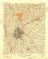
~ Greenville SC topo map, 1:62500 scale, 15 X 15 Minute, Historical, 1938, updated 1948
Greenville, South Carolina, USGS topographic map dated 1938.
Includes geographic coordinates (latitude and longitude). This topographic map is suitable for hiking, camping, and exploring, or framing it as a wall map.
Printed on-demand using high resolution imagery, on heavy weight and acid free paper, or alternatively on a variety of synthetic materials.
Topos available on paper, Waterproof, Poly, or Tyvek. Usually shipping rolled, unless combined with other folded maps in one order.
- Product Number: USGS-5388784
- Free digital map download (high-resolution, GeoPDF): Greenville, South Carolina (file size: 10 MB)
- Map Size: please refer to the dimensions of the GeoPDF map above
- Weight (paper map): ca. 55 grams
- Map Type: POD USGS Topographic Map
- Map Series: HTMC
- Map Verison: Historical
- Cell ID: 54846
- Scan ID: 261857
- Imprint Year: 1948
- Survey Year: 1935
- Datum: NAD27
- Map Projection: Polyconic
- Map published by United States Geological Survey
- Map Language: English
- Scanner Resolution: 600 dpi
- Map Cell Name: Greenville
- Grid size: 15 X 15 Minute
- Date on map: 1938
- Map Scale: 1:62500
- Geographical region: South Carolina, United States
Neighboring Maps:
All neighboring USGS topo maps are available for sale online at a variety of scales.
Spatial coverage:
Topo map Greenville, South Carolina, covers the geographical area associated the following places:
- Cleveland Forest - Donaldson Heights - Pebble Creek - Sunny Acres - Sugar Creek Villas - Stone Lake - Dove Tree - Bird Fields - Sans Souci Heights - Sunset Forest - Parkwood - Northwood Hills - City View - Hermitage Hills - Glendale - Oak Hills - Woodhedge - Northwood - Oak Crest - Forest View - Burgiss Hills - Stone Lake Heights - North Hills - North Side Heights - Monaghan - Mountain Shadows - Sunny Slopes - Cavalier Woods - Dreher Colony - Cedar Lane Gardens - Roosevelt Heights - Oak Hollow - East Highland Estates - Parkins Lake - Lake Forest Heights - Mountain View Homes - Enchanted Forest - Woodland Homes - Cane Brake - Greenville - Tanglewood - Paris (historical) - Westcliffe - Gantt - Quail Haven - Club Forest - Pinehurst - View Point Place - Shady Creek - Brookfield East - Parker - Franklin Hills - Lakeside - The Highlands - Supreme Forest - Milford - Carolina Heights - Merrifield Park - Nursery (historical) - Creekside Villas - Adams Mill Estates - Lorena Park - Morningside - Palmetto Downs - Westville - Fairview - Kingsgate - Fern Creek - White Horse Heights - Alta Vista - Green Hills - Knollwood - Renfrew - Walkers Crossing - Roseman Heights - Dell Vista Heights - Del Norte Estates - Foxcroft - Staunton Heights - Farmington Acres - Woodberry - Woodfields - Sharon Park - Woodfield Heights - Bellwood Estates - Riverdowns - Park Place - Silver Leaf - Merchant Estates - Crosswell - Biltmore - Rogers Valley Heights - Augusta Acres - White Oak - Starsdale Manor - Broadleaf Acres - Orchard Park - Cutler Ridge - Jamestown Estates - Wildaire
- Map Area ID: AREA3534.75-82.5-82.25
- Northwest corner Lat/Long code: USGSNW35-82.5
- Northeast corner Lat/Long code: USGSNE35-82.25
- Southwest corner Lat/Long code: USGSSW34.75-82.5
- Southeast corner Lat/Long code: USGSSE34.75-82.25
- Northern map edge Latitude: 35
- Southern map edge Latitude: 34.75
- Western map edge Longitude: -82.5
- Eastern map edge Longitude: -82.25


