
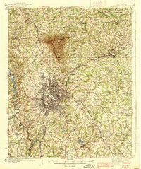
~ Greenville SC topo map, 1:62500 scale, 15 X 15 Minute, Historical, 1938
Greenville, South Carolina, USGS topographic map dated 1938.
Includes geographic coordinates (latitude and longitude). This topographic map is suitable for hiking, camping, and exploring, or framing it as a wall map.
Printed on-demand using high resolution imagery, on heavy weight and acid free paper, or alternatively on a variety of synthetic materials.
Topos available on paper, Waterproof, Poly, or Tyvek. Usually shipping rolled, unless combined with other folded maps in one order.
- Product Number: USGS-5388782
- Free digital map download (high-resolution, GeoPDF): Greenville, South Carolina (file size: 11 MB)
- Map Size: please refer to the dimensions of the GeoPDF map above
- Weight (paper map): ca. 55 grams
- Map Type: POD USGS Topographic Map
- Map Series: HTMC
- Map Verison: Historical
- Cell ID: 54846
- Scan ID: 261856
- Woodland Tint: Yes
- Survey Year: 1935
- Datum: NAD27
- Map Projection: Polyconic
- Map published by United States Geological Survey
- Map Language: English
- Scanner Resolution: 600 dpi
- Map Cell Name: Greenville
- Grid size: 15 X 15 Minute
- Date on map: 1938
- Map Scale: 1:62500
- Geographical region: South Carolina, United States
Neighboring Maps:
All neighboring USGS topo maps are available for sale online at a variety of scales.
Spatial coverage:
Topo map Greenville, South Carolina, covers the geographical area associated the following places:
- Chick Springs - Pine Hill Village - Stratton Place - Fairview - North Acres - Chestnut Hills - Royal Oaks - Kingsgate - Piney Ridge - Forrester Woods - White Oak Hills - View Point Place - Grey Fox Run - Pleasant Valley - Wildaire - Terra Oaks - Cavalier Woods - Montclaire - College Heights - White Horse - Wade Hampton - Mountain Shadows - Seven Oaks - Green Fields - Crosswell - Oak Hollow - Knollwood - Green Hills - Huntington Acres - Kendall Green - Piedmont Park - Boyce Lawn - Woodberry - Quail Ridge - Stone Lake - Northwood Hills - Cavalier Heights - Fern Creek - Points North - Holly Springs - Collins Creek - Stoneledge - Leawood - White Oak - Buxton - Del Norte Estates - Rockvale - Ricelan Creek - Woodland Homes - Starsdale Manor - Oak View - Minter - Laurel Hills - Greenville - Oak Creek - Brookforest Estates - Pinehurst - Knollwood - Camelot - Shady Creek - Roosevelt Heights - Biltmore - Welcome Acres - Creekside Villas - Stone Lake Heights - Glenwood Acres - Carver Park - Spring Forest - High View Acres - Sunny Acres - Elizabeth Heights - Elleston Acres - Spring Forest - Paris (historical) - Northwood - Dunean - Sunset Forest - Woods (historical) - University Ridge Homes - Lorena Park - Cane Brake - Sunny Acres - Franklin Hills - Adams Mill Estates - University Heights - Marshall Forest - Westcliffe - Paramount Park - Laurel Heights - Mountain Brook - Lake Taro - Gower Estates - Montclair - Hampton Heights - Pecan Terrace - Overbrook - Judson - Forestdale Heights - Merchant Estates - Carolina Heights
- Map Area ID: AREA3534.75-82.5-82.25
- Northwest corner Lat/Long code: USGSNW35-82.5
- Northeast corner Lat/Long code: USGSNE35-82.25
- Southwest corner Lat/Long code: USGSSW34.75-82.5
- Southeast corner Lat/Long code: USGSSE34.75-82.25
- Northern map edge Latitude: 35
- Southern map edge Latitude: 34.75
- Western map edge Longitude: -82.5
- Eastern map edge Longitude: -82.25


