
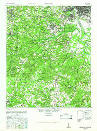
~ Edmund SC topo map, 1:62500 scale, 15 X 15 Minute, Historical, 1944, updated 1966
Edmund, South Carolina, USGS topographic map dated 1944.
Includes geographic coordinates (latitude and longitude). This topographic map is suitable for hiking, camping, and exploring, or framing it as a wall map.
Printed on-demand using high resolution imagery, on heavy weight and acid free paper, or alternatively on a variety of synthetic materials.
Topos available on paper, Waterproof, Poly, or Tyvek. Usually shipping rolled, unless combined with other folded maps in one order.
- Product Number: USGS-5388726
- Free digital map download (high-resolution, GeoPDF): Edmund, South Carolina (file size: 9 MB)
- Map Size: please refer to the dimensions of the GeoPDF map above
- Weight (paper map): ca. 55 grams
- Map Type: POD USGS Topographic Map
- Map Series: HTMC
- Map Verison: Historical
- Cell ID: 53751
- Scan ID: 261827
- Imprint Year: 1966
- Woodland Tint: Yes
- Aerial Photo Year: 1943
- Field Check Year: 1944
- Datum: NAD27
- Map Projection: Polyconic
- Map published by United States Geological Survey
- Map Language: English
- Scanner Resolution: 600 dpi
- Map Cell Name: Edmund
- Grid size: 15 X 15 Minute
- Date on map: 1944
- Map Scale: 1:62500
- Geographical region: South Carolina, United States
Neighboring Maps:
All neighboring USGS topo maps are available for sale online at a variety of scales.
Spatial coverage:
Topo map Edmund, South Carolina, covers the geographical area associated the following places:
- Melwood - Baskin Hills - Charwood - Land of the Lakes - Kinsler - Pineridge - Hillside - Indian Pines - Springdale - Arthurtown - Coventry Woods - Westgate - Congaree (historical) - Apollo Gardens - Lexington Woods - Macedon - Arthur - West Columbia - Oak Crest - Oak Grove Estates - Glenn Village - Spring Hill - Testo - Westwood - Lakewood - Styx (historical) - Hamlet West - Blue Ridge Terrace - Sharpes Hill - Three Fountains - Oakwood - Shandon - Southgate - River Bluff Estates - Kings Grant - Crystal View - Starmount - Greyland Forest - Dutchman Acres - Wrenwood - Dixiana - Happytown - Olympia - Edenwood - Silver Lake - Enos - Gaston - Heritage Hills - Red Bank - Oakridge - Harrisburg - Hollywood - New Dublin (historical) - Honeywood - Cedarwood - Congaree Gardens - Parkwood - Arborgate - Hamlet South - Regency Square - Brookwood - Peachtree Acres - Walnut Creek - Cedar Estates - South Congaree - Rose Gardens - Shuler (historical) - Oak Grove - Shadblow - Edmund - Grandview Estates - Lexington - Lakeview Terrace - Westcliff Estates - Cayce - Woodsen - Lloydswoods - Wales Garden - Westwood - Pelion - Parkway Place - Fairhill
- Map Area ID: AREA3433.75-81.25-81
- Northwest corner Lat/Long code: USGSNW34-81.25
- Northeast corner Lat/Long code: USGSNE34-81
- Southwest corner Lat/Long code: USGSSW33.75-81.25
- Southeast corner Lat/Long code: USGSSE33.75-81
- Northern map edge Latitude: 34
- Southern map edge Latitude: 33.75
- Western map edge Longitude: -81.25
- Eastern map edge Longitude: -81


