
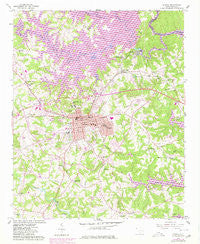
~ Seneca SC topo map, 1:24000 scale, 7.5 X 7.5 Minute, Historical, 1958, updated 1980
Seneca, South Carolina, USGS topographic map dated 1958.
Includes geographic coordinates (latitude and longitude). This topographic map is suitable for hiking, camping, and exploring, or framing it as a wall map.
Printed on-demand using high resolution imagery, on heavy weight and acid free paper, or alternatively on a variety of synthetic materials.
Topos available on paper, Waterproof, Poly, or Tyvek. Usually shipping rolled, unless combined with other folded maps in one order.
- Product Number: USGS-5388224
- Free digital map download (high-resolution, GeoPDF): Seneca, South Carolina (file size: 15 MB)
- Map Size: please refer to the dimensions of the GeoPDF map above
- Weight (paper map): ca. 55 grams
- Map Type: POD USGS Topographic Map
- Map Series: HTMC
- Map Verison: Historical
- Cell ID: 40564
- Scan ID: 261546
- Imprint Year: 1980
- Woodland Tint: Yes
- Photo Revision Year: 1980
- Aerial Photo Year: 1977
- Edit Year: 1980
- Field Check Year: 1958
- Datum: NAD27
- Map Projection: Polyconic
- Map published by United States Geological Survey
- Map Language: English
- Scanner Resolution: 600 dpi
- Map Cell Name: Seneca
- Grid size: 7.5 X 7.5 Minute
- Date on map: 1958
- Map Scale: 1:24000
- Geographical region: South Carolina, United States
Neighboring Maps:
All neighboring USGS topo maps are available for sale online at a variety of scales.
Spatial coverage:
Topo map Seneca, South Carolina, covers the geographical area associated the following places:
- Greenbriar - Shiloh - Singing Pines - Loran Point - Hampton Shores - Thriftwood - Valley View Shores - Lake Barcroft Acres - Walnut Grove - Shadwick - Martindale - Brookwood - The Meadows - Grover Square - Fairview Shores - Spring Valley - Keowee Haven - Keowee Plantation - Clovis Point - Oxford - White Oak Cliffs - Woodfarm Acres - Courtenay - Village Creek - Royal Acres - Return - Springbrook - Bounty Land - Cherokee Gardens - Seneca Landing - Woodland Acres - Newry - Poplar Cove - Sunset Shores - Shiloh Estates - South Cove - Fairview - Keowee Shores - The Woods - Utica - George Martin Acres - Southern Meadows - Dalton - Water Plantation - Ridgeview - Wexford - Hanover Hills - Jordonia - Mylintee Estates - Normandy Shores - Vista Grove - Clemson Forest - Port Santorini - Valley View - Lakeview Heights - Friendship - Bent Tree - Woodcreek - Rackley - Forest Hills - Woodburn - Colonial Place - Indian Hills - Seneca - Enchanted Hills - Keowee - Ridgewood - Cleveland-A-Farm - Millbrook - Bishop Heights - Eleven Oaks - Doris Heights - Harbin Acres - Gilstrap - Knoll Wood Manor - Fox Run - Corinth - Cove Inlet - Indian Oaks
- Map Area ID: AREA34.7534.625-83-82.875
- Northwest corner Lat/Long code: USGSNW34.75-83
- Northeast corner Lat/Long code: USGSNE34.75-82.875
- Southwest corner Lat/Long code: USGSSW34.625-83
- Southeast corner Lat/Long code: USGSSE34.625-82.875
- Northern map edge Latitude: 34.75
- Southern map edge Latitude: 34.625
- Western map edge Longitude: -83
- Eastern map edge Longitude: -82.875


