
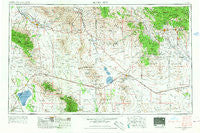
~ Silver City NM topo map, 1:250000 scale, 1 X 2 Degree, Historical, 1954, updated 1967
Silver City, New Mexico, USGS topographic map dated 1954.
Includes geographic coordinates (latitude and longitude). This topographic map is suitable for hiking, camping, and exploring, or framing it as a wall map.
Printed on-demand using high resolution imagery, on heavy weight and acid free paper, or alternatively on a variety of synthetic materials.
Topos available on paper, Waterproof, Poly, or Tyvek. Usually shipping rolled, unless combined with other folded maps in one order.
- Product Number: USGS-5386530
- Free digital map download (high-resolution, GeoPDF): Silver City, New Mexico (file size: 18 MB)
- Map Size: please refer to the dimensions of the GeoPDF map above
- Weight (paper map): ca. 55 grams
- Map Type: POD USGS Topographic Map
- Map Series: HTMC
- Map Verison: Historical
- Cell ID: 69031
- Scan ID: 193069
- Imprint Year: 1967
- Woodland Tint: Yes
- Aerial Photo Year: 1954
- Edit Year: 1962
- Field Check Year: 1954
- Datum: Unstated
- Map Projection: Transverse Mercator
- Map published by United States Geological Survey
- Map Language: English
- Scanner Resolution: 600 dpi
- Map Cell Name: Silver City
- Grid size: 1 X 2 Degree
- Date on map: 1954
- Map Scale: 1:250000
- Geographical region: New Mexico, United States
Neighboring Maps:
All neighboring USGS topo maps are available for sale online at a variety of scales.
Spatial coverage:
Topo map Silver City, New Mexico, covers the geographical area associated the following places:
- Fox - Hext Place - Thatcher - Cliff - Cedar Grove (historical) - Taylor Place - Pima - Dos Cabezas - Willcox - Kimball - Mangas Springs - Mitchell Place - Whitewater - Lebanon - Raso - Whitlock Cienega - Cork - North Hurley - Ulmoris - East Camp (historical) - Shakespeare - Silver Acres - Wimsattville - Santa Rita (historical) - Hollywood - Sid Place - McGhee Wells - Duncan - San Simon - Valley View Mobile Home and Recreational Vehicle Park - San Jose - Wheeler Place - Edgal Place - Sunrise Village Mobile Home Park - Steins - Eden - Three Way - Aragon Place - Lone Star - Little Franks - Alhambra (historical) - Masons Mill (historical) - Sanchez - Silver City - Safford - Riverside - Brockman - Gripe - Safford Ranch Mobile Home Park - Tower Mobile Home Park - Olga - Cotton City - White Signal - McKelvey Place - Old Columbine - Fort Bayard - Vanadium - Lexington Pines Mobile Home Park - Arenas Valley - Mondel - Kansas Settlement - Gold Hill (historical) - Glenbar - Fierro - Bowie - Swift Trail Junction - Separ - Bowie Junction (historical) - Artesia - Chaney Place - Moore Place - Hanover - Sheldon - Telegraph (historical) - Buena Vista - Gary - Hanover Junction - Union Hill - Valedon - Central - Guess Place - Estes Place - Franklin - Santa Clara - Steeplerock (historical) - Yellow Hammer Mill - Bayard - Leitendorf (historical) - Ivanhoe (historical) - Black Hawk (historical) - Guthrie - Central - Tanque - Santiago Silver Creek Mobile Home Park - Gage - Little Walnut Village - Lisbon - Gunn Place (historical) - Redstone - Graham
- Map Area ID: AREA3332-110-108
- Northwest corner Lat/Long code: USGSNW33-110
- Northeast corner Lat/Long code: USGSNE33-108
- Southwest corner Lat/Long code: USGSSW32-110
- Southeast corner Lat/Long code: USGSSE32-108
- Northern map edge Latitude: 33
- Southern map edge Latitude: 32
- Western map edge Longitude: -110
- Eastern map edge Longitude: -108


