
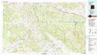
~ Zuni NM topo map, 1:100000 scale, 30 X 60 Minute, Historical, 1981, updated 1991
Zuni, New Mexico, USGS topographic map dated 1981.
Includes geographic coordinates (latitude and longitude). This topographic map is suitable for hiking, camping, and exploring, or framing it as a wall map.
Printed on-demand using high resolution imagery, on heavy weight and acid free paper, or alternatively on a variety of synthetic materials.
Topos available on paper, Waterproof, Poly, or Tyvek. Usually shipping rolled, unless combined with other folded maps in one order.
- Product Number: USGS-5386198
- Free digital map download (high-resolution, GeoPDF): Zuni, New Mexico (file size: 28 MB)
- Map Size: please refer to the dimensions of the GeoPDF map above
- Weight (paper map): ca. 55 grams
- Map Type: POD USGS Topographic Map
- Map Series: HTMC
- Map Verison: Historical
- Cell ID: 72213
- Scan ID: 194772
- Imprint Year: 1991
- Woodland Tint: Yes
- Aerial Photo Year: 1978
- Edit Year: 1981
- Datum: NAD27
- Map Projection: Universal Transverse Mercator
- Map published by United States Geological Survey
- Map Language: English
- Scanner Resolution: 600 dpi
- Map Cell Name: Zuni
- Grid size: 30 X 60 Minute
- Date on map: 1981
- Map Scale: 1:100000
- Geographical region: New Mexico, United States
Neighboring Maps:
All neighboring USGS topo maps are available for sale online at a variety of scales.
Spatial coverage:
Topo map Zuni, New Mexico, covers the geographical area associated the following places:
- Sawyer - North Chaves - Polich Place - Aragon - Bread Springs - Sanchez Place - Copperton - South Chaves - Zuni Pueblo - Chi Chil Tah - Black Rock - Merrill Place - South Guam - Page - Upper Nutria - Continental Divide - Tinaja - Defiance - Zuni - Basgal Place - Fort Wingate - Gonzales - Ramah - Boon Place - Diener - North Guam - Sand Corner - Pueblito - Navarre Place - Grubisich Place - Pescado - Coolidge - Tekapo - Lower Nutria - El Morro - Pinehaven - Thoreau - Vanderwagen - El Morro - Red Rock - McGaffey - Ciniza - Sundance - Prewitt - Paxton Springs (historical) - Manuelito
- Map Area ID: AREA35.535-109-108
- Northwest corner Lat/Long code: USGSNW35.5-109
- Northeast corner Lat/Long code: USGSNE35.5-108
- Southwest corner Lat/Long code: USGSSW35-109
- Southeast corner Lat/Long code: USGSSE35-108
- Northern map edge Latitude: 35.5
- Southern map edge Latitude: 35
- Western map edge Longitude: -109
- Eastern map edge Longitude: -108


