
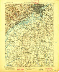
~ Camden NJ topo map, 1:125000 scale, 30 X 30 Minute, Historical, 1901
Camden, New Jersey, USGS topographic map dated 1901.
Includes geographic coordinates (latitude and longitude). This topographic map is suitable for hiking, camping, and exploring, or framing it as a wall map.
Printed on-demand using high resolution imagery, on heavy weight and acid free paper, or alternatively on a variety of synthetic materials.
Topos available on paper, Waterproof, Poly, or Tyvek. Usually shipping rolled, unless combined with other folded maps in one order.
- Product Number: USGS-5377616
- Free digital map download (high-resolution, GeoPDF): Camden, New Jersey (file size: 10 MB)
- Map Size: please refer to the dimensions of the GeoPDF map above
- Weight (paper map): ca. 55 grams
- Map Type: POD USGS Topographic Map
- Map Series: HTMC
- Map Verison: Historical
- Cell ID: 65110
- Scan ID: 255435
- Survey Year: 1894
- Datum: Unstated
- Map Projection: Unstated
- Map published by United States Geological Survey
- Map Language: English
- Scanner Resolution: 600 dpi
- Map Cell Name: Camden
- Grid size: 30 X 30 Minute
- Date on map: 1901
- Map Scale: 1:125000
- Geographical region: New Jersey, United States
Neighboring Maps:
All neighboring USGS topo maps are available for sale online at a variety of scales.
Spatial coverage:
Topo map Camden, New Jersey, covers the geographical area associated the following places:
- Mullica Hill - White Village - Marcus Hook - Aura - Pine Ridge - Woodstown - Friendship - Delair Junction - Vernon - West Collingswood Heights - Herwood - Claymont Heights - Garnet Valley - Grubbs Corner - Kingsessing - Alverno Valley Farms - Adele - Garnet Oaks - Moylan-Rose Valley Station - Swedesboro - University City - Ogden - Sunset Beach - Penton - Monroeville - Avendale - Haddon - Marplewood Villa - Wellwood - Overlook Colony - Greentree - Knowlton - Bells Lake - Husted - Old Mill Pointe - Upper Providence - Crum Creek Manor - Fork Landing - Green-Fields - Coopertown (historical) - Gwinhurst - Parry - Rutledge - Parkridge at Bellevue - West Village - Valley View - Haddon Hills - Fishtown - Westinghouse Village - Claymont Manor - Wynnefield - Beckett - Sewell - Cohansey - Millbridge - Tavistock - Leonards - Paradise Lakes - Glassboro - Sinnickson Landing - Essington - Paschall - Jessups Mill - Seabrook Farms - Upland - Lawnside - Centre City - Northcrest - Academy - Somerdale - Mantua - Riverside - Pedricktown - Rose Tree - Parkside - Fisher Corners - Norwood - Feltonville - Primos - Morris - Sharon Hill - Terrestria - Sharswood - Poplar - Remsterville - Rulon Road - Malaga - Girard Estate - Boothwyn - Auburn - Hartranft - Claymont - Woodstream Gardens - Tomlin - Rose Run Estates - Springfield - Forest Grove - Northern Liberties - Wrights Mill - Verga
- Map Area ID: AREA4039.5-75.5-75
- Northwest corner Lat/Long code: USGSNW40-75.5
- Northeast corner Lat/Long code: USGSNE40-75
- Southwest corner Lat/Long code: USGSSW39.5-75.5
- Southeast corner Lat/Long code: USGSSE39.5-75
- Northern map edge Latitude: 40
- Southern map edge Latitude: 39.5
- Western map edge Longitude: -75.5
- Eastern map edge Longitude: -75


