
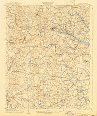
~ Springhope NC topo map, 1:62500 scale, 15 X 15 Minute, Historical, 1904, updated 1942
Springhope, North Carolina, USGS topographic map dated 1904.
Includes geographic coordinates (latitude and longitude). This topographic map is suitable for hiking, camping, and exploring, or framing it as a wall map.
Printed on-demand using high resolution imagery, on heavy weight and acid free paper, or alternatively on a variety of synthetic materials.
Topos available on paper, Waterproof, Poly, or Tyvek. Usually shipping rolled, unless combined with other folded maps in one order.
- Product Number: USGS-5374682
- Free digital map download (high-resolution, GeoPDF): Springhope, North Carolina (file size: 7 MB)
- Map Size: please refer to the dimensions of the GeoPDF map above
- Weight (paper map): ca. 55 grams
- Map Type: POD USGS Topographic Map
- Map Series: HTMC
- Map Verison: Historical
- Cell ID: 62865
- Scan ID: 164604
- Imprint Year: 1942
- Survey Year: 1902
- Datum: Unstated
- Map Projection: Polyconic
- Map published by United States Geological Survey
- Map Language: English
- Scanner Resolution: 600 dpi
- Map Cell Name: Spring Hope
- Grid size: 15 X 15 Minute
- Date on map: 1904
- Map Scale: 1:62500
- Geographical region: North Carolina, United States
Neighboring Maps:
All neighboring USGS topo maps are available for sale online at a variety of scales.
Spatial coverage:
Topo map Springhope, North Carolina, covers the geographical area associated the following places:
- Middlesex - Mount Pleasant - Hunts - Sims - Union Hope - Frazier Crossroads - Batchelor Crossroads - Lamm Crossroads - Seven Paths - Lamm - Murraytown - High Crossroads - Taylor Crossroads - Old Spring Hope - Rogers Crossroads - Pine Ridge - Daddysville - Spring Hope - Stanhope - Samaria - Oakland - Social Plains - White Oak - Old Stanhope (historical) - Bass Crossroads - Floods Chapel - Tants Crossroads - Momeyer - Gold Valley Crossroads - Strickland Crossroads - Rocky Cross - Bailey
- Map Area ID: AREA3635.75-78.25-78
- Northwest corner Lat/Long code: USGSNW36-78.25
- Northeast corner Lat/Long code: USGSNE36-78
- Southwest corner Lat/Long code: USGSSW35.75-78.25
- Southeast corner Lat/Long code: USGSSE35.75-78
- Northern map edge Latitude: 36
- Southern map edge Latitude: 35.75
- Western map edge Longitude: -78.25
- Eastern map edge Longitude: -78


