
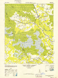
~ South Mills NC topo map, 1:62500 scale, 15 X 15 Minute, Historical, 1952
South Mills, North Carolina, USGS topographic map dated 1952.
Includes geographic coordinates (latitude and longitude). This topographic map is suitable for hiking, camping, and exploring, or framing it as a wall map.
Printed on-demand using high resolution imagery, on heavy weight and acid free paper, or alternatively on a variety of synthetic materials.
Topos available on paper, Waterproof, Poly, or Tyvek. Usually shipping rolled, unless combined with other folded maps in one order.
- Product Number: USGS-5374672
- Free digital map download (high-resolution, GeoPDF): South Mills, North Carolina (file size: 7 MB)
- Map Size: please refer to the dimensions of the GeoPDF map above
- Weight (paper map): ca. 55 grams
- Map Type: POD USGS Topographic Map
- Map Series: HTMC
- Map Verison: Historical
- Cell ID: 62794
- Scan ID: 164549
- Woodland Tint: Yes
- Aerial Photo Year: 1940
- Datum: NAD27
- Map Projection: Polyconic
- Map published by United States Geological Survey
- Map Language: English
- Scanner Resolution: 600 dpi
- Map Cell Name: South Mills
- Grid size: 15 X 15 Minute
- Date on map: 1952
- Map Scale: 1:62500
- Geographical region: North Carolina, United States
Neighboring Maps:
All neighboring USGS topo maps are available for sale online at a variety of scales.
Spatial coverage:
Topo map South Mills, North Carolina, covers the geographical area associated the following places:
- Fauna (historical) - Parkville - Forest Park - Jackson Corner - Johnsons Corner - McPhersons Mobile Home Park - Lilly - Oxford Heights - Chapanoke - Morgans Corners - Lynchs Corner - Nicanor - Chesterfield Heights - Hintonsville (historical) - Briarwood - Sharon - Whiteston - Ulster Gardens - Horseshoe - Burnt Mills - Chapell Gardens - Tar Corner - South Mills - Hickory Acres - Brays Estate - Mobile Home Park - Lebanon Mobile Home Park - Pierceville - Elizabeth City - Okisko - Pasquotank - Lumber Mill
- Map Area ID: AREA36.536.25-76.5-76.25
- Northwest corner Lat/Long code: USGSNW36.5-76.5
- Northeast corner Lat/Long code: USGSNE36.5-76.25
- Southwest corner Lat/Long code: USGSSW36.25-76.5
- Southeast corner Lat/Long code: USGSSE36.25-76.25
- Northern map edge Latitude: 36.5
- Southern map edge Latitude: 36.25
- Western map edge Longitude: -76.5
- Eastern map edge Longitude: -76.25


