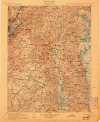
~ Patuxent MD topo map, 1:125000 scale, 30 X 30 Minute, Historical, 1906
Patuxent, Maryland, USGS topographic map dated 1906.
Includes geographic coordinates (latitude and longitude). This topographic map is suitable for hiking, camping, and exploring, or framing it as a wall map.
Printed on-demand using high resolution imagery, on heavy weight and acid free paper, or alternatively on a variety of synthetic materials.
Topos available on paper, Waterproof, Poly, or Tyvek. Usually shipping rolled, unless combined with other folded maps in one order.
- Product Number: USGS-5368682
- Free digital map download (high-resolution, GeoPDF): Patuxent, Maryland (file size: 12 MB)
- Map Size: please refer to the dimensions of the GeoPDF map above
- Weight (paper map): ca. 55 grams
- Map Type: POD USGS Topographic Map
- Map Series: HTMC
- Map Verison: Historical
- Cell ID: 66296
- Scan ID: 257741
- Survey Year: 1897
- Datum: Unstated
- Map Projection: Unstated
- Map published by United States Geological Survey
- Map Language: English
- Scanner Resolution: 600 dpi
- Map Cell Name: Patuxent
- Grid size: 30 X 30 Minute
- Date on map: 1906
- Map Scale: 1:125000
- Geographical region: Maryland, United States
Neighboring Maps:
All neighboring USGS topo maps are available for sale online at a variety of scales.
Spatial coverage:
Topo map Patuxent, Maryland, covers the geographical area associated the following places:
- Acco Park - Larkington - Paris Estates - Hyattsville Hills - Sylvanhurst - Green Landing - Hampshire Knolls - Castlemore - Windcliff - Randolph Village - Sunderland - Kettering - Suitland - Bell Haven - The Village - Twin Lakes - River Club Estates - Central Village - Silver Hill Park - Twin Hills - Prince Frederick - Hawthorne Woods - Breezy Point - Bess-Mar Estates - Glen Isle - Walnut Hills - Brookside - Calvert Estates - Hunting Lake - Knolland - Friendship Woods - Elen Acres - Ponder Cove - Locust Grove Beach - Garfield Heights - Gallant Green Woods - Lincoln Heights - Holt Manor - Bayard - Dunkirk Fields - Market Quay - Merrywood - Karen Knolls - Columbia Park - Oxon Hill - South River Towers - Benedict - Fairfax Village - Sharperville - Cedarlea - Rutland Estates - Turkey Ridge - Howes Meadows - North Indian Creek Estates - Calvert Chase - Springfield - South River Estates - Rolling Acres - Oakland Estates - Dunleigh - Hunt Chapel - Lord Calvert Hills - The Alameda - Twin Shields Estates - Carriage Hills - Chapel Knoll - Tiffany Woods - North Deale - Trails - Arnold Heights - Mount Rainier - Lincoln Heights - Loretta Heights - Tara - Smithville - Benning - Owensville - Pine Grove Estates - Silver Hill - Southdown Estates - Painters Hill - Parker Meadows - Ashwood Manor - Berwyn - Rolling Glen Farms - Langdon - Bellewood - Cedar Lawn - Acton Village - Dillon Park - Plainview Gardens - Huntingtown Meadows - Overbrook - Oak Hill Estates - Woodland - Aquasco - Croom Acres - Clinton Heights - D'Arcy Hills - Castle Manor
- Map Area ID: AREA3938.5-77-76.5
- Northwest corner Lat/Long code: USGSNW39-77
- Northeast corner Lat/Long code: USGSNE39-76.5
- Southwest corner Lat/Long code: USGSSW38.5-77
- Southeast corner Lat/Long code: USGSSE38.5-76.5
- Northern map edge Latitude: 39
- Southern map edge Latitude: 38.5
- Western map edge Longitude: -77
- Eastern map edge Longitude: -76.5


