
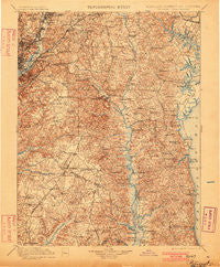
~ Patuxent MD topo map, 1:125000 scale, 30 X 30 Minute, Historical, 1899, updated 1901
Patuxent, Maryland, USGS topographic map dated 1899.
Includes geographic coordinates (latitude and longitude). This topographic map is suitable for hiking, camping, and exploring, or framing it as a wall map.
Printed on-demand using high resolution imagery, on heavy weight and acid free paper, or alternatively on a variety of synthetic materials.
Topos available on paper, Waterproof, Poly, or Tyvek. Usually shipping rolled, unless combined with other folded maps in one order.
- Product Number: USGS-5368678
- Free digital map download (high-resolution, GeoPDF): Patuxent, Maryland (file size: 12 MB)
- Map Size: please refer to the dimensions of the GeoPDF map above
- Weight (paper map): ca. 55 grams
- Map Type: POD USGS Topographic Map
- Map Series: HTMC
- Map Verison: Historical
- Cell ID: 66296
- Scan ID: 257739
- Imprint Year: 1901
- Survey Year: 1897
- Datum: Unstated
- Map Projection: Unstated
- Map published by United States Geological Survey
- Map Language: English
- Scanner Resolution: 600 dpi
- Map Cell Name: Patuxent
- Grid size: 30 X 30 Minute
- Date on map: 1899
- Map Scale: 1:125000
- Geographical region: Maryland, United States
Neighboring Maps:
All neighboring USGS topo maps are available for sale online at a variety of scales.
Spatial coverage:
Topo map Patuxent, Maryland, covers the geographical area associated the following places:
- Willie Breeze - Queen Anne Knolls - Edgewood Terrace - Waldorf - Windcliff - University Park - Swanson Creek Landing - Idlewood Park - Neeld Estates - Radcliffe - Brookridge Manor - Woodwind Estates - Lincoln - Lancaster - Cape Loch Haven - Smithville - Old Ford Hills - Willow Gate - Pushaw (historical) - Brown - Acco Park - Westphalia - Velmeade - Holland Cliff Shores - Bryantown Estates - Broadwater - Garfield Heights - Holiday Beach - Tyrol Estates - Largo - Lake Karylbrook - Huntingtown - Valley Lee - Edelen Estates - Parran Hunt Estates - Stafford - Cedarlea - Pine Trailer Park - Westphalia Estates - Bolton - Bellemead - Oak Hill Estates - The Highlands - Castlemore - Dupont Heights - Lakeside Mews - Sunrise - Mariners Cove - Hampshire - White Hall - Cedarwood - Lincoln Park - Bell - Deale Beach - Wuthering Heights - Rolling Acres - Summer City - Hunting Hills - Chillum - Piscataway - Berkshire - Goddard - Cheverly - Autumn Chase at Riva Trace - Pleasant Springs - Spring Oak Estates - Century Estates - Buena Vista on the Patuxent - Three Brothers - Bradbury Heights - Eickelberry Woods - Fort Lincoln New Town - Mattawoman - Grantham Hall - Rutland - Barnaby Manor Oaks - Patuxent River Estates - Kirkwood - Cape Anne - Hambleton - Hermitage Hill - Boones Mobile Estates - Camp Springs - Cedar Lawn - Paris Estates - Autumn Estates - Radcliffe Estates - Heather Knolls - Collington - Ardwick - Branchville - Dorchester - Portland Manor - Ashford - Williamsburg Estates - North Michigan Park - Maxwelton - Coxby Estates - Lofty Heights - Wakefield
- Map Area ID: AREA3938.5-77-76.5
- Northwest corner Lat/Long code: USGSNW39-77
- Northeast corner Lat/Long code: USGSNE39-76.5
- Southwest corner Lat/Long code: USGSSW38.5-77
- Southeast corner Lat/Long code: USGSSE38.5-76.5
- Northern map edge Latitude: 39
- Southern map edge Latitude: 38.5
- Western map edge Longitude: -77
- Eastern map edge Longitude: -76.5


