
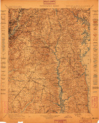
~ Patuxent MD topo map, 1:125000 scale, 30 X 30 Minute, Historical, 1899
Patuxent, Maryland, USGS topographic map dated 1899.
Includes geographic coordinates (latitude and longitude). This topographic map is suitable for hiking, camping, and exploring, or framing it as a wall map.
Printed on-demand using high resolution imagery, on heavy weight and acid free paper, or alternatively on a variety of synthetic materials.
Topos available on paper, Waterproof, Poly, or Tyvek. Usually shipping rolled, unless combined with other folded maps in one order.
- Product Number: USGS-5368676
- Free digital map download (high-resolution, GeoPDF): Patuxent, Maryland (file size: 11 MB)
- Map Size: please refer to the dimensions of the GeoPDF map above
- Weight (paper map): ca. 55 grams
- Map Type: POD USGS Topographic Map
- Map Series: HTMC
- Map Verison: Historical
- Cell ID: 66296
- Scan ID: 257738
- Survey Year: 1897
- Datum: Unstated
- Map Projection: Unstated
- Map published by United States Geological Survey
- Map Language: English
- Scanner Resolution: 600 dpi
- Map Cell Name: Patuxent
- Grid size: 30 X 30 Minute
- Date on map: 1899
- Map Scale: 1:125000
- Geographical region: Maryland, United States
Neighboring Maps:
All neighboring USGS topo maps are available for sale online at a variety of scales.
Spatial coverage:
Topo map Patuxent, Maryland, covers the geographical area associated the following places:
- Maryland Mobile Estates - Mary E White Estate - Sunderland Park - Queensland - Lakewood Estates - Pendleton - Wuthering Heights - Radcliffe Estates - Owings Hills - Gatts Corner - Broadwater - Crofton Woods - North Avondale - North Deale - Lakeland - Whiskey Bottom - Overbrook - Columbia Park - Monastery Lot (historical) - MacDonald Farms - Sunnyside - Ireland Estates - Patuxent Mobile Estates - Ardwick - Kavadias Estates - Acton Village - Academy Hill - Mill Swamp - Harkness Creek Park - Courtney Manor - Fort Davis - Auth Village - Bladensburg - Tranquility - Bay Ridge Junction - Bellewood - Chesapeake Beach - Rolee Estates - Sunderland Estates - Cheston - Walnut Hills - Pin Oak Village - Land Tree - Wood Haven Park - Oakwood - Hickory Ridge - Sudley - Carmody Hills - Kings Manor South - Dunkirk Fields - Melwood Mobile Home Park - Woodmore - Dupont Park - Oakland Acres - Pigeon House Corner - Greater Capitol Heights - Willowbrook Hills - Cox - Flower Village Mobile Home Park - Davidsonville - Lake Karylbrook - Randle Cliff Beach - Heather Woods - Dixon Estates - College Heights Estates - Sudleys Choice - Warrlinda - Scientists Cliffs - Kingman Park - South River Spring Lakes - Bel Air Acres - Homewood - College Park - Paris Oaks - Cottage City - The Alameda - Clahamman Hills - Warburton Oaks - Hughesville Manor - Heather Knolls - Ashbox - Bowen Estates - Calvert Towne - Davidsonville Woods - Parrans Woods - Bell Haven - Riva Trace - Bryantown - Simpsons Farm - Glen Oak - Weestwood Estates - Woodland Acres - Eickelberry Woods - Old Fort Acres - Patuxent River Estates - Hidden Cove - North Kenilworth - Anacostia - Sam Owings Place - Brandywine
- Map Area ID: AREA3938.5-77-76.5
- Northwest corner Lat/Long code: USGSNW39-77
- Northeast corner Lat/Long code: USGSNE39-76.5
- Southwest corner Lat/Long code: USGSSW38.5-77
- Southeast corner Lat/Long code: USGSSE38.5-76.5
- Northern map edge Latitude: 39
- Southern map edge Latitude: 38.5
- Western map edge Longitude: -77
- Eastern map edge Longitude: -76.5


