
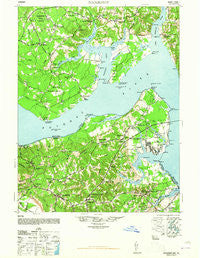
~ Nanjemoy MD topo map, 1:62500 scale, 15 X 15 Minute, Historical, 1948
Nanjemoy, Maryland, USGS topographic map dated 1948.
Includes geographic coordinates (latitude and longitude). This topographic map is suitable for hiking, camping, and exploring, or framing it as a wall map.
Printed on-demand using high resolution imagery, on heavy weight and acid free paper, or alternatively on a variety of synthetic materials.
Topos available on paper, Waterproof, Poly, or Tyvek. Usually shipping rolled, unless combined with other folded maps in one order.
- Product Number: USGS-5368342
- Free digital map download (high-resolution, GeoPDF): Nanjemoy, Maryland (file size: 9 MB)
- Map Size: please refer to the dimensions of the GeoPDF map above
- Weight (paper map): ca. 55 grams
- Map Type: POD USGS Topographic Map
- Map Series: HTMC
- Map Verison: Historical
- Cell ID: 58262
- Scan ID: 257536
- Woodland Tint: Yes
- Aerial Photo Year: 1943
- Datum: NAD27
- Map Projection: Transverse Mercator
- Map published by United States Army Corps of Engineers
- Map published by United States Army
- Map Language: English
- Scanner Resolution: 600 dpi
- Map Cell Name: Nanjemoy
- Grid size: 15 X 15 Minute
- Date on map: 1948
- Map Scale: 1:62500
- Geographical region: Maryland, United States
Neighboring Maps:
All neighboring USGS topo maps are available for sale online at a variety of scales.
Spatial coverage:
Topo map Nanjemoy, Maryland, covers the geographical area associated the following places:
- Compton - Nanjemoy - Purkins Corner - Chapel Point - Alden - Hooes - Fairview Beach - Sutton Acres - Wellington Beach - Melody Acres - Simms Landing - Owens - Maryland Point - Grayton - Mount Air - Bristol (historical) - Weedonville - Ambar - King George - Cherryfield (historical) - Cedar Grove - Ninde - Penn Manor - Ironsides - Brentland - Doncaster - Hill Top - Tetotum - Riverside - Friendship Acres - Hampstead - Carruthers Corner - Edgehill - Berthaville - Jacksontown (historical) - Comorn - Allnut - Dahlgren - Osso - Whites Corner - Mount Hope - Marshope - Somerset Beach - Chestnut Hill - Welcome Acres - Presidential Lakes - Hickory Hill - Potomac Shores - Arnolds Corner - Grafton (historical) - Maple Grove
- Map Area ID: AREA38.538.25-77.25-77
- Northwest corner Lat/Long code: USGSNW38.5-77.25
- Northeast corner Lat/Long code: USGSNE38.5-77
- Southwest corner Lat/Long code: USGSSW38.25-77.25
- Southeast corner Lat/Long code: USGSSE38.25-77
- Northern map edge Latitude: 38.5
- Southern map edge Latitude: 38.25
- Western map edge Longitude: -77.25
- Eastern map edge Longitude: -77


