
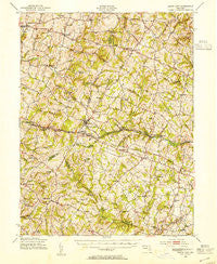
~ Mount Airy MD topo map, 1:62500 scale, 15 X 15 Minute, Historical, 1945, updated 1955
Mount Airy, Maryland, USGS topographic map dated 1945.
Includes geographic coordinates (latitude and longitude). This topographic map is suitable for hiking, camping, and exploring, or framing it as a wall map.
Printed on-demand using high resolution imagery, on heavy weight and acid free paper, or alternatively on a variety of synthetic materials.
Topos available on paper, Waterproof, Poly, or Tyvek. Usually shipping rolled, unless combined with other folded maps in one order.
- Product Number: USGS-5368338
- Free digital map download (high-resolution, GeoPDF): Mount Airy, Maryland (file size: 11 MB)
- Map Size: please refer to the dimensions of the GeoPDF map above
- Weight (paper map): ca. 55 grams
- Map Type: POD USGS Topographic Map
- Map Series: HTMC
- Map Verison: Historical
- Cell ID: 57931
- Scan ID: 257530
- Imprint Year: 1955
- Woodland Tint: Yes
- Aerial Photo Year: 1943
- Field Check Year: 1945
- Datum: NAD27
- Map Projection: Polyconic
- Map published by United States Geological Survey
- Map published by United States Army Corps of Engineers
- Map published by United States Army
- Map Language: English
- Scanner Resolution: 600 dpi
- Map Cell Name: Mount Airy
- Grid size: 15 X 15 Minute
- Date on map: 1945
- Map Scale: 1:62500
- Geographical region: Maryland, United States
Neighboring Maps:
All neighboring USGS topo maps are available for sale online at a variety of scales.
Spatial coverage:
Topo map Mount Airy, Maryland, covers the geographical area associated the following places:
- Lisbon Meadows - Mount Radnor Heights - Cedar Heights Estates - Rosswood Estates - Mullinix - Cedar Heights - Damascus Manor - Ashley Acres - Glenvue Acres - Winfield - Olde Oak Run - Ray-Mar Estates - Duvall Manor - Damascus View - Glenwood - Sweepstakes - Patapsco Overlook - Glisson Place - Rainbow Estates - Dorsey Crossroads - Academy Acres - Twin Maples - Country View - Village of Tall Oaks - Timber Ridge - Harrisville Farmettes - Mount Lebanon - Watersville - Cedar Grove Knolls - South Timber - Justifiable - Buffalo Estates - Christy Acres - Bicentennial Estates - Robindell Heights - Barnett - Fleming Way Estates - Heather Ridge - Carroll Heights - Damascus - Harvest Ridge - Cumorah Estates - Linganore View - Hemp Hills - Brantly - Airport Acres - Oak Orchard - Janwood - Upper Seneca Crest - Blankner Hill - Skyline Woods - Sun Valley Farms - Kittyhawk Estates - Lisbon Manor - Farmfield Estates - Pheasant Ridge Estates - Silver Fern Estates - Southview - Friendship Knolls - Brandon Manor - Park View Estates - Bootjack - Carrs Mill - Ravenwood Estates - Mid Country View - Harrisville Heights - Dill - Villa Tomarchio - Rolling Carroll Estates - Mount Airy - Harmony Hall - Dorceytown - White Rock - Mount Airy Estates - Hawthorne Acres - Fischer - Mountain Vista - Chases Forest - Woodville Meadows - Cabin River Farms - Oldfield - Buckhorn Run - Daniel - Sun Valley - Winfield Woods - Dulany Hills - Dendor Mar Estates - Eyre View - Kingstead Knolls - Morgan - Green Meadows - Lisbon Acres - Bessie Clemson Heights - Tarson Manor - Conestoga Heights - Glenwood Estates - The Heritage - Crampton - Mill Bottom - Kelly Ridge
- Map Area ID: AREA39.539.25-77.25-77
- Northwest corner Lat/Long code: USGSNW39.5-77.25
- Northeast corner Lat/Long code: USGSNE39.5-77
- Southwest corner Lat/Long code: USGSSW39.25-77.25
- Southeast corner Lat/Long code: USGSSE39.25-77
- Northern map edge Latitude: 39.5
- Southern map edge Latitude: 39.25
- Western map edge Longitude: -77.25
- Eastern map edge Longitude: -77


