
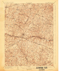
~ Mount Airy MD topo map, 1:62500 scale, 15 X 15 Minute, Historical, 1909, updated 1925
Mount Airy, Maryland, USGS topographic map dated 1909.
Includes geographic coordinates (latitude and longitude). This topographic map is suitable for hiking, camping, and exploring, or framing it as a wall map.
Printed on-demand using high resolution imagery, on heavy weight and acid free paper, or alternatively on a variety of synthetic materials.
Topos available on paper, Waterproof, Poly, or Tyvek. Usually shipping rolled, unless combined with other folded maps in one order.
- Product Number: USGS-5368332
- Free digital map download (high-resolution, GeoPDF): Mount Airy, Maryland (file size: 10 MB)
- Map Size: please refer to the dimensions of the GeoPDF map above
- Weight (paper map): ca. 55 grams
- Map Type: POD USGS Topographic Map
- Map Series: HTMC
- Map Verison: Historical
- Cell ID: 57931
- Scan ID: 257527
- Imprint Year: 1925
- Survey Year: 1907
- Datum: NAD
- Map Projection: Polyconic
- Map published by United States Geological Survey
- Map Language: English
- Scanner Resolution: 600 dpi
- Map Cell Name: Mount Airy
- Grid size: 15 X 15 Minute
- Date on map: 1909
- Map Scale: 1:62500
- Geographical region: Maryland, United States
Neighboring Maps:
All neighboring USGS topo maps are available for sale online at a variety of scales.
Spatial coverage:
Topo map Mount Airy, Maryland, covers the geographical area associated the following places:
- Tolley Terrace - River Farms - Damascus - Olde Oak Run - New Venture Estates - Rolling Hills - Sugarloaf Overlook - Mill Green - Upper Seneca Crest - Bushy Park Estates - Kingstead Knolls - Pheasant Ridge Estates - Piney Run Estates - Ivy Hill Way - Silver Maple Estates - Rolling Hills - Paloma Villa - Spring Garden Estates - Mount Lebanon - Fischer - Ashley Acres - Bushey Heights - Kittyhawk Estates - Harrisville - East Rolling Hills - Daisy - Braddock Estates - White Rock - Hampton Knolls - Benders Heights - Fox Ridge Estates - Dulany Hills - Robindell Heights - Sherwood Forest - Arthur Ridge - Montclare - Heritage - Flag Marsh Heights - Carsan Knolls - Smith Village - Heather Ridge - Daisy Woods - McPherson - Matherwood Heights - County View - Daisy Meadows - Cedar Grove Knolls - Timberleigh Village - Taylorsville - Damascus Valley Estates - Twin Maples - Hickory Hill - Park Lake Estates - Florence - Damascus Hill - Winfield - Lisbon Meadows - Gasnell Estates - South Glen - Highview - Nursery View - Raydan Retreat - Linganore Woods - Clearspring Manor - Harvest Ridge - Mountain Vista - Cumorah Estates - The Heritage - Bootjack - Ritter - Eyre View - Friendship Knolls - Buffalo Estates - Damascus View - Chestnut Oaks - Oak Orchard - Friendship - Oceola Estates - Huntfield - Quail Creek Acres - Winfield Woods - Gwenlee Estates - South Timber - Dendor Mar Estates - Hemp Hills - Gallagher Estates - Glenvue Acres - Linganore View - Fleming Way Estates - Linganore - Winfield Heights - Mount Airy Estates - Woodville Terrace - Red Fox Meadow - Jacobs Run - Rainbow Estates - Vicky Estates - New Estates - South Carroll Estates - Mill Bottom
- Map Area ID: AREA39.539.25-77.25-77
- Northwest corner Lat/Long code: USGSNW39.5-77.25
- Northeast corner Lat/Long code: USGSNE39.5-77
- Southwest corner Lat/Long code: USGSSW39.25-77.25
- Southeast corner Lat/Long code: USGSSE39.25-77
- Northern map edge Latitude: 39.5
- Southern map edge Latitude: 39.25
- Western map edge Longitude: -77.25
- Eastern map edge Longitude: -77


