
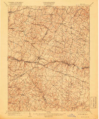
~ Mount Airy MD topo map, 1:62500 scale, 15 X 15 Minute, Historical, 1909, updated 1918
Mount Airy, Maryland, USGS topographic map dated 1909.
Includes geographic coordinates (latitude and longitude). This topographic map is suitable for hiking, camping, and exploring, or framing it as a wall map.
Printed on-demand using high resolution imagery, on heavy weight and acid free paper, or alternatively on a variety of synthetic materials.
Topos available on paper, Waterproof, Poly, or Tyvek. Usually shipping rolled, unless combined with other folded maps in one order.
- Product Number: USGS-5368328
- Free digital map download (high-resolution, GeoPDF): Mount Airy, Maryland (file size: 10 MB)
- Map Size: please refer to the dimensions of the GeoPDF map above
- Weight (paper map): ca. 55 grams
- Map Type: POD USGS Topographic Map
- Map Series: HTMC
- Map Verison: Historical
- Cell ID: 57931
- Scan ID: 257525
- Imprint Year: 1918
- Survey Year: 1907
- Datum: Unstated
- Map Projection: Unstated
- Map published by United States Geological Survey
- Map Language: English
- Scanner Resolution: 600 dpi
- Map Cell Name: Mount Airy
- Grid size: 15 X 15 Minute
- Date on map: 1909
- Map Scale: 1:62500
- Geographical region: Maryland, United States
Neighboring Maps:
All neighboring USGS topo maps are available for sale online at a variety of scales.
Spatial coverage:
Topo map Mount Airy, Maryland, covers the geographical area associated the following places:
- Robindell Heights - Winfield Heights - Diamond View - Damascus Valley Park - Calebs Delight - Cover (historical) - Mount Airy Village West - Grahams Green Acres - Rolling Carroll Estates - Stoney Ridge - Red Fox Meadow - Brandon Manor - Sams Creek - Rainbow Estates - Rover Mill Estates - Shawns Landing - Woodside Estates - Green Meadows - Woodbridge - Knollwood - Roxbury Mills - Nursery View - Fox Ridge Estates - Patapsco Overlook - Sun Valley - Smith Village - Gallagher Estates - Villa Monticello - Eagle Wood Estates - Rosswood Estates - Airy Estates - Farmfield Estates - Molesworth Hills - Highview Estates - Kelly Ridge - Olde Oak Run - Bloom - Glenwood - South Glen - Browningsville - Ronalee Hills - Dorceytown - Glisson Place - Mill Bottom - Merridale Gardens - Park Lake Estates - Fremont Acres - Stanton Heights - Sweepstakes - Village of Tall Oaks - New Port - Wolf Den Spring - Quail Creek Acres - Sherwood Forest - Ivy Hill Way - Windsong Farms - Potomac Estates - Picketts Corner - South Carroll Estates - Carsan Knolls - New Estates - Mount Airy Estates - Florence - Treasure Mountain - McPherson - Mount Airy Estates - Buffalo Estates - Ridgeville - Red Lion Inn Estates - Resourceful Acres - Oak Orchard - Harrisville Heights - Fischer - Daisy Hill Estates - Gasnell Estates - Bartholows - Chestnut Oaks - Harrisville - Mountain Vista - Darby Delight - Shaffers Mill Estates - Damascus - Buckhorn Run - Southview - Arthur Ridge - Atkins Acres - Hickory Ridge - Damascus Manor - Flowerwood Estates - Jennings Chapel Woods - Carrs Mill - Lisbon Manor - Roxbury - Fox Ridge Estates - Skyline Woods - Conestoga Heights - Silver Maple Estates - Damascus Gardens - Mount Lebanon - Rattle Ridge
- Map Area ID: AREA39.539.25-77.25-77
- Northwest corner Lat/Long code: USGSNW39.5-77.25
- Northeast corner Lat/Long code: USGSNE39.5-77
- Southwest corner Lat/Long code: USGSSW39.25-77.25
- Southeast corner Lat/Long code: USGSSE39.25-77
- Northern map edge Latitude: 39.5
- Southern map edge Latitude: 39.25
- Western map edge Longitude: -77.25
- Eastern map edge Longitude: -77


