
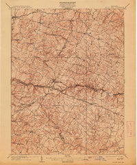
~ Mount Airy MD topo map, 1:62500 scale, 15 X 15 Minute, Historical, 1909, updated 1913
Mount Airy, Maryland, USGS topographic map dated 1909.
Includes geographic coordinates (latitude and longitude). This topographic map is suitable for hiking, camping, and exploring, or framing it as a wall map.
Printed on-demand using high resolution imagery, on heavy weight and acid free paper, or alternatively on a variety of synthetic materials.
Topos available on paper, Waterproof, Poly, or Tyvek. Usually shipping rolled, unless combined with other folded maps in one order.
- Product Number: USGS-5368326
- Free digital map download (high-resolution, GeoPDF): Mount Airy, Maryland (file size: 10 MB)
- Map Size: please refer to the dimensions of the GeoPDF map above
- Weight (paper map): ca. 55 grams
- Map Type: POD USGS Topographic Map
- Map Series: HTMC
- Map Verison: Historical
- Cell ID: 57931
- Scan ID: 257524
- Imprint Year: 1913
- Survey Year: 1907
- Datum: Unstated
- Map Projection: Unstated
- Map published by United States Geological Survey
- Map Language: English
- Scanner Resolution: 600 dpi
- Map Cell Name: Mount Airy
- Grid size: 15 X 15 Minute
- Date on map: 1909
- Map Scale: 1:62500
- Geographical region: Maryland, United States
Neighboring Maps:
All neighboring USGS topo maps are available for sale online at a variety of scales.
Spatial coverage:
Topo map Mount Airy, Maryland, covers the geographical area associated the following places:
- Parrsville - Cedar Grove Knolls - Arthur Ridge - Unionville - Ritz Estates - Cooksville - Kings Valley - Blankner Hill - Justifiable - Flag Marsh Heights - Holler - Merridale - Equestrian Estates - Mount Lebanon - Seneca Springs - Purdum - Hoods Mill - Grahams Green Acres - Rattle Ridge - Kittyhawk Estates - Seneca Overlook - Barnett - Liberty Knolls - South Carroll Estates - Hawthorne Estates - Woodside Estates - Quail Creek Acres - Jaycox - Annapolis Rock - Morgan - Sugarloaf Overlook - Long Corner - Dotsons Ridge - Red Fox Meadow - Bessie Clemson Heights - Gosnell - Dennings - Sundown Manor - Windsong Farms - West Oak Fields - Buffalo Estates - Buckhorn Run - Stoney Ridge - Benders Heights - New Venture Estates - Christy Acres - Chestnut Oaks - Gilboa - Glenvue Acres - Stanton Heights - Diamond View - Park View Estates - Hanford Estates - Harrisville Farmettes - Clearspring Manor - Bicentennial Estates - Daisy Meadows - Olde Washington Valley - Stonelake - Cedar Heights - Mount Airy Overview Estates - Timber Ridge - Harrisville - Rolling Carroll Estates - Harvest Ridge - Park Lake Estates - Kingstead Knolls - The Heritage - Roxbury - Harrisville Heights - Kabik Korner - Heather Ridge - Heritage - Damascus Valley Park - Knollwood - Southview - Ronalee Hills - Latigo Trails - Silver Maple Estates - Glenwood - Fox Ridge Estates - Etchison - Bennett Manor - Barrett - Darby Delight - New Estates - Friendship - Lisbon Meadows - Ashley Mobile Home Park - Samhill Estates - Paloma Villa - Hazels Woods - Bloom - Brandon Manor - Ridgeville - Florence - Watersville - Poignant Acres - Tarson Manor - Winfield Woods
- Map Area ID: AREA39.539.25-77.25-77
- Northwest corner Lat/Long code: USGSNW39.5-77.25
- Northeast corner Lat/Long code: USGSNE39.5-77
- Southwest corner Lat/Long code: USGSSW39.25-77.25
- Southeast corner Lat/Long code: USGSSE39.25-77
- Northern map edge Latitude: 39.5
- Southern map edge Latitude: 39.25
- Western map edge Longitude: -77.25
- Eastern map edge Longitude: -77


