
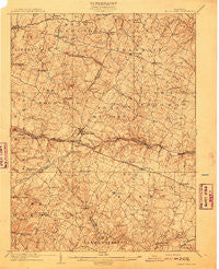
~ Mount Airy MD topo map, 1:62500 scale, 15 X 15 Minute, Historical, 1909
Mount Airy, Maryland, USGS topographic map dated 1909.
Includes geographic coordinates (latitude and longitude). This topographic map is suitable for hiking, camping, and exploring, or framing it as a wall map.
Printed on-demand using high resolution imagery, on heavy weight and acid free paper, or alternatively on a variety of synthetic materials.
Topos available on paper, Waterproof, Poly, or Tyvek. Usually shipping rolled, unless combined with other folded maps in one order.
- Product Number: USGS-5368324
- Free digital map download (high-resolution, GeoPDF): Mount Airy, Maryland (file size: 10 MB)
- Map Size: please refer to the dimensions of the GeoPDF map above
- Weight (paper map): ca. 55 grams
- Map Type: POD USGS Topographic Map
- Map Series: HTMC
- Map Verison: Historical
- Cell ID: 57931
- Scan ID: 257523
- Survey Year: 1907
- Datum: Unstated
- Map Projection: Unstated
- Map published by United States Geological Survey
- Map Language: English
- Scanner Resolution: 600 dpi
- Map Cell Name: Mount Airy
- Grid size: 15 X 15 Minute
- Date on map: 1909
- Map Scale: 1:62500
- Geographical region: Maryland, United States
Neighboring Maps:
All neighboring USGS topo maps are available for sale online at a variety of scales.
Spatial coverage:
Topo map Mount Airy, Maryland, covers the geographical area associated the following places:
- Daisy Meadows - Clearspring Manor - Samhill Estates - Grahams Green Acres - Justifiable - Flag Marsh Heights - Brantly - Barnett - Mid Country View - Candice Estates - Linganore Woods - Mount Airy Overview Estates - New Estates - Stanton Heights - Piney Run Estates - Gosnell - Janwood - Cooksville - Kittyhawk Estates - Brandon Manor - Country View - Bicentennial Estates - Fleming Way Estates - County View - Bennett Manor - Dorceytown - Chestnut Oaks - Mill Green - Green Meadows - Cedar Heights Estates - Park View Estates - Buffalo Hills - Southview - Bootjack - Eyre View - Kingstead Knolls - Braddock Manor West - River Plantations - Airy Estates - Daniel - Gwenlee Estates - Glisson Place - Shawns Landing - Dennings - Monks Misery - Villa Tomarchio - Kemptown - Wolf Den Spring - Sun Valley Farms - Nottingham Village - Long Corner - Lisbon Acres - Knollwood - Pheasant Ridge Estates - Kings Valley Manor - Mount Airy - Woodbine Acres - Hickory Ridge - Barrett - Unionville - Heise - Woodville - Upper Seneca Crest - Bushy Park Estates - Manahan (historical) - Etchison - Covers Corner - Bloom - Airport Acres - Fair Wind Estates - Ravenwood Estates - Blankner Hill - Diamond View - Rolling Hills - Gasnell Estates - Winfield Heights - Fox Ridge Estates - Conestoga Heights - Highview - Hawthorne Acres - Spring Garden Estates - South Carroll Estates - Florence - Hungerford Manor - Lisbon Meadows - Harrisville Farmettes - Molesworth Hills - Mill Bottom - Byrons Manor - The Heritage - Daisy Woods - McHenry Meadows - Hipsleys Mill - Merridale Gardens - Smith Village - Franklinville - Fuller - Vicky Estates - Hoods Mill - Seneca Overlook
- Map Area ID: AREA39.539.25-77.25-77
- Northwest corner Lat/Long code: USGSNW39.5-77.25
- Northeast corner Lat/Long code: USGSNE39.5-77
- Southwest corner Lat/Long code: USGSSW39.25-77.25
- Southeast corner Lat/Long code: USGSSE39.25-77
- Northern map edge Latitude: 39.5
- Southern map edge Latitude: 39.25
- Western map edge Longitude: -77.25
- Eastern map edge Longitude: -77


