
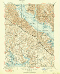
~ Leonardtown MD topo map, 1:62500 scale, 15 X 15 Minute, Historical, 1939, updated 1951
Leonardtown, Maryland, USGS topographic map dated 1939.
Includes geographic coordinates (latitude and longitude). This topographic map is suitable for hiking, camping, and exploring, or framing it as a wall map.
Printed on-demand using high resolution imagery, on heavy weight and acid free paper, or alternatively on a variety of synthetic materials.
Topos available on paper, Waterproof, Poly, or Tyvek. Usually shipping rolled, unless combined with other folded maps in one order.
- Product Number: USGS-5368308
- Free digital map download (high-resolution, GeoPDF): Leonardtown, Maryland (file size: 11 MB)
- Map Size: please refer to the dimensions of the GeoPDF map above
- Weight (paper map): ca. 55 grams
- Map Type: POD USGS Topographic Map
- Map Series: HTMC
- Map Verison: Historical
- Cell ID: 56657
- Scan ID: 257514
- Imprint Year: 1951
- Edit Year: 1950
- Survey Year: 1936
- Datum: NAD
- Map Projection: Polyconic
- Map published by United States Geological Survey
- Map Language: English
- Scanner Resolution: 600 dpi
- Map Cell Name: Leonardtown
- Grid size: 15 X 15 Minute
- Date on map: 1939
- Map Scale: 1:62500
- Geographical region: Maryland, United States
Neighboring Maps:
All neighboring USGS topo maps are available for sale online at a variety of scales.
Spatial coverage:
Topo map Leonardtown, Maryland, covers the geographical area associated the following places:
- Holly Gaf Acres - Hollywood - Home Place - Oraville - Britton - Mechanicsville - Lancaster Hill - Laurel Grove - Quiet Acres - Helen Farmettes - Kenwood Beach - Riverwood Farms - Pinemore - Saint Andrews Estates - Cremona - Huntersville - Olde Mill - Oakley - Redgate - Shamrock Glen Estates - Goodwins - Halls Hacienda - Collingwood - Gillens Grove - Hillside Manor - Hillville - Rolling Acres - Buzzard Point - Mackall Estates - Fox Hill - Queen Tree Landing - Blue Dolphin Estates - Saint Margarets Grove - Tenn Wood Acres - Middle Earth - Land-O-Lakes - Newtown (historical) - Oakville - Matapeake - Briscoe - Mutual Estates - Barefoot Acres - Shady Dale - Hellen - Pawpaw Hollow - Harbor Hills - Helen - Woodland Acres - Hollywood Shores - Parker Wharf - Holly Acres - Williams Wharf - Society Hill - Mount Pleasant - Foxwell Point - Honey Cove Estates - Morganza - Widow Woods - Laceys Venture - Patuxent Knolls - Sandgates - Western Shores - Mutual - Birch Manor - Big Oak - Beauvue - Wildwood - California - Abell - Island Creek - Wallville - Myrtle Point - Saint Marys Beach - Loveville - Clements - Sotterley - Emerald Cove - Maryland Gardens - Summerseat Village - Nostalgia - Bowens - King-Kennedy Estates - Mutual Consent - North Town Creek Manor - Battle (historical) - Clarks Landing - Wells Cove - Forest Glade - Wildewood - Drumcliff - Cal Acres - Cooney Neck Estate - Ross Woods - Holly Oaks - Follywoods - Fenwick Manor - Scotch Point - Hidden River - Chippingwood - Mackall
- Map Area ID: AREA38.538.25-76.75-76.5
- Northwest corner Lat/Long code: USGSNW38.5-76.75
- Northeast corner Lat/Long code: USGSNE38.5-76.5
- Southwest corner Lat/Long code: USGSSW38.25-76.75
- Southeast corner Lat/Long code: USGSSE38.25-76.5
- Northern map edge Latitude: 38.5
- Southern map edge Latitude: 38.25
- Western map edge Longitude: -76.75
- Eastern map edge Longitude: -76.5


