
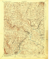
~ Laurel MD topo map, 1:62500 scale, 15 X 15 Minute, Historical, 1926
Laurel, Maryland, USGS topographic map dated 1926.
Includes geographic coordinates (latitude and longitude). This topographic map is suitable for hiking, camping, and exploring, or framing it as a wall map.
Printed on-demand using high resolution imagery, on heavy weight and acid free paper, or alternatively on a variety of synthetic materials.
Topos available on paper, Waterproof, Poly, or Tyvek. Usually shipping rolled, unless combined with other folded maps in one order.
- Product Number: USGS-5368282
- Free digital map download (high-resolution, GeoPDF): Laurel, Maryland (file size: 9 MB)
- Map Size: please refer to the dimensions of the GeoPDF map above
- Weight (paper map): ca. 55 grams
- Map Type: POD USGS Topographic Map
- Map Series: HTMC
- Map Verison: Historical
- Cell ID: 56580
- Scan ID: 257501
- Survey Year: 1915
- Datum: NAD
- Map Projection: Polyconic
- Map published by United States Geological Survey
- Map Language: English
- Scanner Resolution: 600 dpi
- Map Cell Name: Laurel
- Grid size: 15 X 15 Minute
- Date on map: 1926
- Map Scale: 1:62500
- Geographical region: Maryland, United States
Neighboring Maps:
All neighboring USGS topo maps are available for sale online at a variety of scales.
Spatial coverage:
Topo map Laurel, Maryland, covers the geographical area associated the following places:
- Mission Heights - Harpers Choice - Talbott Springs - Running Brook - Washington Manor Park - Jericho Park - Pembroke Knolls - Spencerville Knolls - North Laurel Park - Rolling Acres - Paint Branch Estates - Hammond Hills - Montpelier Woods - La Isla - Paint Branch Farms - Whitehouse - Phelps Luck - Hollywood Park - Haviland Hills - Oxford Green - Montpelier Forest - Sharewood Acres - Cliftonbrook - Village of Deep Run - Cedar Knoll Farms - Braeburn - Parkway Hills Mobile Home Park - Avenel - Ednor Acres - Green Hill Manor - Jessup - Cabin Hill - Scotchtown Hills - Thompsons Purchase - Savage - Hawthorn North - Ednor - Oak Crest - Allnut Farms Estates - Blackburn Village - Beltsville Heights - Hollywood - Brightfield - Nordeau - Hallmark - Oakland Mills - Glenshire Towne - Village of Dorseys Search - Burnt Mills Hills - Castlegate - Riverside - Rosedale Park - Pine Valley - Foxhall Villas - Browns Corner - Woodland Village - Guilford - Villages of Montpelier - Colony Fairfield - Glen Oaks - Sniders Estates - Fairknoll - Hillandale Heights - Settlers Landing - Heritage Woods - Guilford Downs - Dogwood - Muirkirk - Beech Creek - Spencerville - Huntington East - Montgomery Run - Scott Acres - Swansfield - Wood Ridge - Hopewell - Worthington - Evemar Mobile Home Park - Greencastle Manor - Ednor Farms - Brighton Pines - Kindler Estates - Clarys Forest - Colesville Heights - Farside - Woodleigh - Hawthorn - Garrian Orchards - Robeys Farmlets - Clarksville - Clemens Crossing - Good Hope - Cherrywood - Birchwood Gardens - Long Reach - Champion Forest - Oak View Village - Forest Hills - Holly Tree Estates - McCahill Estates
- Map Area ID: AREA39.2539-77-76.75
- Northwest corner Lat/Long code: USGSNW39.25-77
- Northeast corner Lat/Long code: USGSNE39.25-76.75
- Southwest corner Lat/Long code: USGSSW39-77
- Southeast corner Lat/Long code: USGSSE39-76.75
- Northern map edge Latitude: 39.25
- Southern map edge Latitude: 39
- Western map edge Longitude: -77
- Eastern map edge Longitude: -76.75


