
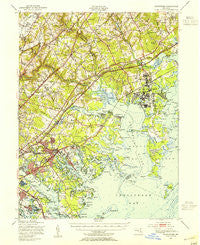
~ Gunpowder MD topo map, 1:62500 scale, 15 X 15 Minute, Historical, 1949, updated 1955
Gunpowder, Maryland, USGS topographic map dated 1949.
Includes geographic coordinates (latitude and longitude). This topographic map is suitable for hiking, camping, and exploring, or framing it as a wall map.
Printed on-demand using high resolution imagery, on heavy weight and acid free paper, or alternatively on a variety of synthetic materials.
Topos available on paper, Waterproof, Poly, or Tyvek. Usually shipping rolled, unless combined with other folded maps in one order.
- Product Number: USGS-5368212
- Free digital map download (high-resolution, GeoPDF): Gunpowder, Maryland (file size: 9 MB)
- Map Size: please refer to the dimensions of the GeoPDF map above
- Weight (paper map): ca. 55 grams
- Map Type: POD USGS Topographic Map
- Map Series: HTMC
- Map Verison: Historical
- Cell ID: 54940
- Scan ID: 257455
- Imprint Year: 1955
- Woodland Tint: Yes
- Aerial Photo Year: 1947
- Field Check Year: 1949
- Datum: NAD27
- Map Projection: Polyconic
- Map published by United States Geological Survey
- Map published by United States Army Corps of Engineers
- Map published by United States Army
- Map Language: English
- Scanner Resolution: 600 dpi
- Map Cell Name: Gunpowder
- Grid size: 15 X 15 Minute
- Date on map: 1949
- Map Scale: 1:62500
- Geographical region: Maryland, United States
Neighboring Maps:
All neighboring USGS topo maps are available for sale online at a variety of scales.
Spatial coverage:
Topo map Gunpowder, Maryland, covers the geographical area associated the following places:
- Briarwood Estate - Mount Bush Estates - Cool Breeze Mobile Home Park - Glen Arm - Sylvania Mobile Home Park - Sleepy Hollow Mobile Home Park - Glenwood Trailer Park - Forge Acres - Singer - Hopkins Landing - White Marsh - The Meadows - Baldwin Estates - Hartland Run - Ballard Gardens - Glenmar - The Pointe - Emmorton - The Cedars - Berkfield - Lou Mar Estates - Harbour Oaks - Lawrence Hill - Valley View - Harford Mobile Village - Bradford Barrens - Joppa - Reckford - Seneca Park - The Timbers - Clayton Manor - Clear Acres - Ivy Hill - Valleybrook - Upper Falls - Wilna - Kenwood Farm Estates - Crisfield Crossing - Stemmers Run - Broadview - Long Green Woods - Edgewater Village - Evergreen Park - Oaks of Harford - Woodlea - Harford Manor - Rossville - Hydes - Lereley - Annes Delight - Stockton - Perry Hall Village - Williams Mobile Home Park - Darryl Gardens - Rivershore - West Shore - Fontana Village - Harewood - Victory Villa - Greenwood - Joppa View - McComas - Village of Pawner - Willoughby Court - Merrywood - Hallfield Manor - Bradshaw - Clearview - Grimesdale - Perry's Mobile Home Park - Woodale Homes - Perryvale - Woodcrest - Jenkins - Tremper Farm - Woodsdale Meadows - Scholar Woods - Marys Choice - Turkey Point - Bird River Beach - Correlli Estates - Joppa Landing - Sue Creek Landing - Silver Meadow - Magnolia Estates Mobile Home Park - Crestwood Acres - Mountvista - Gray Haven - Southfield at Whitemarsh - Marine Oak Village - Germantown - Jerusalem Mills - Middlesex - Laurel Valley - Franklinville - Green Acres - Walnut Hills Estates - Joppatowne - Perry Hall Manor - Oakdale
- Map Area ID: AREA39.539.25-76.5-76.25
- Northwest corner Lat/Long code: USGSNW39.5-76.5
- Northeast corner Lat/Long code: USGSNE39.5-76.25
- Southwest corner Lat/Long code: USGSSW39.25-76.5
- Southeast corner Lat/Long code: USGSSE39.25-76.25
- Northern map edge Latitude: 39.5
- Southern map edge Latitude: 39.25
- Western map edge Longitude: -76.5
- Eastern map edge Longitude: -76.25


